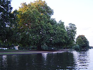
Rivermead Island
| Rivermead Island | ||
|---|---|---|
| Rivermead Island from the river | ||
| Waters | Thames | |
| Geographical location | 51 ° 24 ′ N , 0 ° 24 ′ W | |
|
|
||
| Residents | uninhabited | |
| Rivermead Island parkland | ||
Rivermead Island is a flat, grassy island in the River Thames above Molesey Lock at Sunbury-on-Thames , Surrey , England . Most of the island is part of the Spelthorne County and a small part of the Elmbridge Borough Council .
geography
There is a tree-lined meadow on the island, and the edges are heavily bushed. The site is common property and freely accessible as part of the Metropolitan Green Belt . From an inside banks stop opposite the Thames Path can walk to the Sunbury Lock see. The island is connected to the mainland by a pedestrian bridge, and during dry periods it is accessible by four-wheel drive vehicles through a ford . Today's Rivermead Island originally consisted of two islands. The smaller island at the downstream end was called Swan's Rest and has been permanently connected since the late 20th century. This part belongs to Elmbridge as its fishing rights were once transferred there.
At just 9 meters above sea level as opposed to the 10 meters ( ASL ) for most roads in Sunbury, the island is often flooded.
See also
Individual evidence
- ^ A b Interactive Maps Surrey County Council.
- ↑ Streetmap boundary and detailed facilities map.Retrieved April 15, 2015.


