Rodde (Rheine)
|
Rodde
City of Rheine
Coordinates: 52 ° 17 ′ 3 ″ N , 7 ° 31 ′ 45 ″ E
|
||
|---|---|---|
| Height : | 41 m | |
| Residents : | 1648 (December 31, 2015) | |
| Postal code : | 48432 | |
| Area code : | 05459 and 05971 | |
|
Location of Rodde in North Rhine-Westphalia |
||
Rodde is a district of the Rhine and is located in the northern Münsterland . At the end of 2015 Rodde had 1648 inhabitants.
geography
Rodde is framed between the Rhine districts of Altenrheine, Eschendorf and Gellendorf in the west, Elte in the south. The Münsterland / Tecklenburger Land border runs to the west and north of Rodde. In the Tecklenburger Land , Rodde borders Bevergern in the east and Hörstel in the north .
Rodde is cut through by the Löhne – Rheine railway line and the Dortmund-Ems canal . Rodde itself is divided into three parts: Fernrodde in the east on the border with Bevergern, the place Rodde itself and Nahrodde with the Rheine canal port.
history

The Rodder once moved to the nearby Netherlands to work there. Even today, the Hollandgänger linden tree on Nahrodder Strasse is a reminder. When the Dortmund-Ems Canal developed from 1852 to 1895, they finally found work on site. The construction of the railroad in Rodde from 1853 to 1855 also had an impact on this. At the same time, more and more roads ran through Rodde and connected the village with the outside world. In the 1960s there were grocery stores, restaurants, post offices, fire brigade and police, butchers, tailors, hairdressers, carpenters, driving schools, savings banks, gas stations and drinks dealers in Rodde. However, these have almost completely disappeared from the district to this day.
traffic
Rodde is well connected in terms of transport. Until a few years ago there was a stop on the railway called: Rodde (Westf.) . It was given up in June 1991 due to insufficient passenger numbers and the proximity to the Rheine and Hörstel train stations . The Rheine Canal Harbor is an industrial park in the district. Here goods are reloaded onto the Dortmund-Ems Canal. The former narrow-gauge railway Tecklenburger Nordbahn runs through the canal harbor and over the canal towards Rheine . It was re-gauged in 1935 and has only been used to transport goods since passenger traffic was discontinued in the 1970s.
The A 30 motorway runs north of Rodde. There is a junction called Rheine Canal Harbor here .
economy
More than 80 small and medium-sized companies are based in Rodde, around 50 of which are based in the Kanalhafen industrial park.
Culture
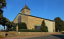
The Catholic parish of St. Josef Rodde is located in the village itself. There is also a kindergarten (St. Joseph) and a primary school (Rodde sub-location of the Canisius primary school). Rodde has around 15 clubs and associations in total. Including the sports club Eintracht Rodde, the women's community, the Schützenverein Rodde 1847, the Kolping Club Rodde, the Schützenbruderschaft Kanalhafen, TC "Rodde Igels" eV, Rodder scratch brushes, the Rodde Heimatverein and many more. The Rodde canal lock was combined with the Bevergern lock with a combination lock - it is now operated fully automatically from Bergeshövede. There is also a wind orchestra that was founded in 1924 and today consists of over 60 musicians, most of them very young. In 2013 Rodde got his own logo from the ProRodde initiative: "Rodde - of course!".
Web links
- Internet presence of Rodde
- Rodde (Rheine) in the Westphalia Culture Atlas

