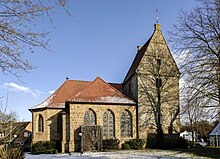
Elte (Rheine)
|
Elte
City of Rheine
|
||
|---|---|---|
| Coordinates: 52 ° 14 ′ 35 ″ N , 7 ° 31 ′ 20 ″ E | ||
| Height : | 37 m | |
| Area : | 26.52 km² | |
| Residents : | 2198 (Dec. 31, 2014) | |
| Population density : | 83 inhabitants / km² | |
| Incorporation : | 1st January 1975 | |
| Postal code : | 48432 | |
| Area code : | 05975 | |
|
Location of Elte in North Rhine-Westphalia |
||
The place Elte is a district of Rheine in the North Rhine-Westphalian district of Steinfurt .
location and size
Elte currently has around 2197 inhabitants (as of December 31, 2014). The main roads through Elte are the B475 from Warendorf to Rheine and the L578 from Steinfurt . In the west of Elte, the Ems forms a natural border with Mesum . In the south Elte borders on Emsdetten , in the north lies the core city Rheine . Bevergern and Riesenbeck are direct neighbors to the east .
history
The name "Elte"
The name "Elte" was first mentioned in a document from 1154. In the “Codex traditionum” which is kept in the State Archives in Münster , Volume VI on page 181 reads: “ Bishop Werner von Münster ” founded an Augustinian monastery in Asbeck in 1140. The noble Eppo von Burgsteinfurt donated two manses (courtyards) to this monastery, located in parochia Rene in villa quae "Elethe'dicitur".
The linguists interpret all place and field names with the endings èthè and èdè as heath areas. In the course of time, the vernacular gave the village the name "Elte".
At the beginning of the Second World War, from February 1940, troops of the 227th Infantry Division were quartered in Elte and the surrounding area (Rheine / Gronau area) . This area served the division as a staging area before it took part in the case of Gelb (the 1st part of the western campaign) on May 10, 1940 .
Incorporation
On January 1, 1975 Elte was incorporated into Rheine.
Schools and kindergartens
In Elte there is the Catholic Ludgerus kindergarten.
The Ludgerus School was first mentioned in a document in 1792. Today's Catholic Confessional Primary School is currently 1.5-speed and has around 130 students. The school offers care from 7.30 a.m. to 2.00 p.m. In 2007 the school won 4th place in the nationwide competition "Kids in the company" and in the same year was named the safest school in the Steinfurt district (11th place among more than 1,600 schools in the Westphalia-Lippe Regional Association). The most famous students were the religious philosopher Josef Pieper and the painter of the New Leipzig School, Matthias Weischer.
traffic
The city bus line C6 runs in Elte, which connects Elte with the bus meeting point in Rheine and with Mesum. After the bus service ends in the evening, collective call taxis leave Elte.
particularities
- Elte won the 2008 Golddorf competition “Our village should be more beautiful”.
- The "Bockholter Ems ferry" is one of the last non-motorized ferries on the Ems. It connects Elte with the other side of the Ems, which belongs to Emsdetten-Isendorf.
- Half-timbered yard in Pöpping in Elte
- The Elter Fischteiche nature reserve (5.81 ha) extends to the east and the Flöddert nature reserve (13.69 ha ) and Elter Dünen (26.66 ha) to the south-east .
- In the list of architectural monuments in Rheine , ten monuments are listed for Elte .
The church
The parish church of Elte is a building from the 17th century in Gothic style, the tower from the Romanesque is much older. An extension was made in the 1920s. Most of the furnishings are in the baroque style.
Sons and daughters
- Josef Pieper (1904–1997), Christian philosopher, university professor in Münster
- Matthias Weischer (* 1973), painter, representative of the so-called New Leipzig School
Web links
- www.elte.de
- Elte in the Westphalia Culture Atlas
Individual evidence
- ↑ Development of the population. Retrieved March 28, 2015 .
- ^ Federal Statistical Office (ed.): Historical municipality directory for the Federal Republic of Germany. Name, border and key number changes in municipalities, counties and administrative districts from May 27, 1970 to December 31, 1982 . W. Kohlhammer, Stuttgart / Mainz 1983, ISBN 3-17-003263-1 , p. 317 .


