
Rohrauerhaus
| Rohrauerhaus NFI shelter |
||
|---|---|---|
 Rohrauerhaus, in the background the Great Pyhrgas |
||
| Mountain range | Ennstal Alps | |
| Regions | Hall walls | |
| Geographical location: | 47 ° 38 '15.4 " N , 14 ° 23' 27.4" E | |
| Altitude | 1308 m above sea level A. | |
|
||
| owner | Friends of nature Austria, local group Linz | |
| Built | 1925 | |
| Construction type | Refuge | |
| Usual opening times | In summer from the beginning of May to the end of October; in winter on request | |
| accommodation | 26 beds, 23 camps | |
| Winter room | On demand | |
| Hut directory | NFI DAV | |

The Rohrauerhaus is located in the municipality of Spital am Pyhrn in Upper Austria , Austria . It is a refuge for Austria's friends of nature . It stands at 1308 m above sea level in the area of the Haller Walls . The way to the hut is, among other things, a section of the European long-distance hiking trail E4 and the Austrian long-distance hiking trail 01 (Northern Alpine Trail ). The hut was opened in 1925 and is named after Alois Rohrauer, the co-founder of the Naturfreunde tourist association . The house burned down in 1933 and, due to the political situation in the corporate state and during the time of National Socialism in Austria, it could only be repaired from 1955 and reopened in 1957.
Tour possibilities
- The three-hut hike from the parking lot at the former Grünau inn through the Dr. Vogelgesang gorge to the Bosruckhütte and via the Rohrauerhaus to the Hofalmhütte . From there back to the starting point, total walking time approx. 5 hours
- Around the Karleck ( 1582 m ) via the private Ardningalmhütte ( 1037 m ) and the Arlingsattel ( 1425 m ) in approx. 3 hours
- Via Arlingsattel ( 1425 m ) to Ardning or via the Pyhrgasgatterl ( 1308 m ) to Hall near Admont in approx. 2 hours
Approaches
- from the parking lot at the Bosruckhütte in about 1 hour
- from the parking lot at the former inn Grünau ( 725 m ) through the Dr. Vogelgesang gorge in approx. 2¼ hours
- from Spital am Pyhrn train station ( 650 m ) in approx. 3 hours
- from Admont via Mühlau in approx. 3½ hours
- from Ardning train station in approx. 3 hours
Mountaineering
- Großer Pyhrgas ( 2244 m ) via the partially insured Hofersteig (path 615) in approx. 3 hours
- Großer Pyhrgas over the west ridge (path 614) in approx. 3 hours
- Scheiblingstein ( 2197 m ) in about 3¾ hours
- Bosruck ( 1992 m ) over a via ferrata of difficulty A / B, partially exposed
Transitions to neighboring huts
- to the Bosruckhütte ( 1036 m ) in about 1 hour
- to the Hofalmhütte ( 1305 m ) over the Hofalmsattel in about ¾ hours
- to the Ardningalmhütte (snack station) ( 1037 m ) in about 1½ hours
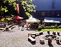
Children's arena of the Rohrauerhaus

Literature & Maps
- Günter and Luise Auferbauer: Gesäuse with Eisenerzer Alps , Bergverlag Rudolf Rother , Munich 2012, 5th edition. ISBN 978-3-7633-4213-6
- Gerald Radinger: Hiking experience in the Kalkalpen National Park. The most beautiful tours between Enns and Steyr. Kral Verlag, 2012, ISBN 978-3-99024-066-3
- Freytag & Berndt u. Artaria KG Publishing and Distribution WK 062 Gesäuse - Ennstaler Alpen - Schoberpass, hiking map 1: 50,000
- ÖK 50, sheet 99 (Rottenmann)
Web links
- Club news. Hut opening. In: Der Naturfreund , born 1925, XXIX. Volume, p. 103, bottom left. (Online at ANNO ).
- Strohmann, J .: The eventful history of the Rohrauerhaus. In: Windischgarstener Kurier. Werbering Windischgarsten, September 2009, accessed on August 5, 2015 .
- www.naturfreunde-haeuser.net
- Homepage Rohrauerhaus