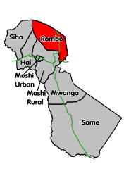
Rombo (district)
| Rombo | |
|---|---|
 |
|
| Basic data | |
| Country | Tanzania |
| Capital | Mkuu |
| surface | 1442 km² |
| Residents | 260,963 (2012) |
| density | 181 inhabitants per km² |
| ISO 3166-2 | TZ-09 |
Coordinates: 3 ° 1 ′ S , 37 ° 28 ′ E
Rombo is a district in the Kilimanjaro region in eastern Tanzania . The district is bordered by Kenya to the north and east , by the Moshi district to the south and by the Hai and Siha districts to the west .
geography
The district has a size of 1442 square kilometers and around 260,000 inhabitants, which corresponds to a population density of 181 people per square kilometer. The administrative center is in the city of Mkuu . The area includes the summit of Kilimanjaro and its northern and eastern slopes up to the border with Kenya. The climate in the district is warm and temperate, Cfa according to the effective climate classification . Precipitation falls all year round, with a peak in April and May; the annual average rains over 1000 millimeters. The temperature is between 20 and 30 degrees Celsius.
Administrative division
The district is divided into 24 parishes (wards):
- Mamsera
- Mahida
- Mengwe
- Keni Mengeni
- Aleni
- Shimbi
- Makiidi
- Kelamfua Mokala
- Ushiri Ikuini
- Mrao Keryo
- Kirwa Keni
- Katangara Mrere
- Kisale Msaranga
- Olele
- Kirongo Samanga
- Kitirima Kingachi
- Ubetu Kahe
- Nanjara rehab
- Tarakea Motamburu
- Motamburu Kitendeni
- Marangu Kitowo
- Ngoyon
- Manda
- Holili
population
The population in Rombo rose from 200,912 in 1988 to 245,716 in 2002 and further to 260,963 in 2012. This corresponds to an average annual growth of around one percent. The literacy rate of those over fifteen was 87.8 percent (as of 2012), two thirds spoke only Swahili , almost one fifth spoke Swahili and English.
Facilities and services
- Education: there are 159 preschool classes and 175 elementary schools in the district for the education of young people, 160 of which are public and 15 private. In the 51 secondary schools in 2017 there were 16,434 students in 41 public schools and 2,797 students in ten private schools.
- Health: The district has two church-run hospitals, six state health facilities and 37 pharmacies. Of these, 21 are state-owned, nine by church organizations and six are privately operated (as of 2019).
- Water: There are 30 springs in the district that deliver 22,000 to 27,000 cubic meters of water per day, depending on the season. The daily requirement is 40,000 cubic meters (as of 2019).
Economy and InfrastructureNinety percent of the population live from agriculture, seven percent are self-employed and three percent are employees (as of 2019). AgricultureOf the total area, 44,114 hectares are arable land, 16,692 hectares are pasture land and 38,194 hectares are forest. The rest is in barren land like the summit of Kilimanjaro. Of the total of 59,000 households in the district, 42,000 kept pets (as of 2012). In 2019, 1.5 million chickens, 128,000 goats and 55,000 sheep were kept. |
 |
Nature reserves, sights
- Kilimanjaro : At 5895 meters, the highest peak in Africa is in the Rombo district. The ascent via the Nalemuru route, which leads through the district, is known.
- Kilimanjaro National Park : This 1668 square kilometer national park was declared a UNESCO World Heritage Site in 1987 .
- Chala Lake : On the border with Kenya, the lake is located in a 3 by 2.4 kilometer crater, the walls of which rise up to a hundred meters. In addition to endemic cichlids, there are 200 species of birds and various monkeys around the lake.
Web links
Individual evidence
- ↑ a b c d Historia | Halmashauri ya Wilaya ya Rombo. Retrieved January 12, 2020 .
- ↑ Contact Us | Halmashauri ya Wilaya ya Rombo. Retrieved January 13, 2020 .
- ↑ Google Maps. Retrieved January 13, 2020 (de-US).
- ↑ Google Maps. Retrieved January 13, 2020 (de-US).
- ↑ Siha climate: Average Temperature, weather by month, Siha weather averages - Climate-Data.org. Retrieved January 13, 2020 .
- ↑ 2012 Population and Housing Census. (PDF) National Bureau of Statistics and Ministry of Finance, March 2013, p. 36 , accessed on January 13, 2020 .
- ↑ Tanzania Regional Profiles, 03 Kilimanjaro Regional Profiles. (pdf) The United Republic of Tanzania, 2016, p. 15 , accessed on January 13, 2020 .
- ↑ Tanzania Regional Profiles, 03 Kilimanjaro Regional Profiles. (pdf) The United Republic of Tanzania, 2016, pp. 68, 72 , accessed on January 13, 2012 .
- ↑ Education Services | Halmashauri ya Wilaya ya Rombo. Retrieved January 13, 2020 (Swahili).
- ↑ Health | Halmashauri ya Wilaya ya Rombo. Retrieved January 13, 2020 .
- ↑ Water Service | Halmashauri ya Wilaya ya Rombo. Retrieved January 13, 2020 (Swahili).
- ↑ Tanzania Regional Profiles, 03 Kilimanjaro Regional Profiles. (pdf) The United Republic of Tanzania, 2016, p. 129 , accessed on January 13, 2012 .
- ↑ Statistics | Halmashauri ya Wilaya ya Rombo. Retrieved January 13, 2020 (Swahili).
- ↑ a b Vivutio vya Utalii | Halmashauri ya Wilaya ya Rombo. Retrieved January 13, 2020 (Swahili).
- ↑ Tanzania in Figures 2018. (PDF) National Bureau of Statistics, June 2019, p. 6 , accessed January 13, 2020 .
- ↑ UNESCO World Heritage Center: Kilimanjaro National Park. Retrieved January 13, 2020 .
- ↑ Mount Kilimanjaro National Park - Tanzania Tourism. Retrieved January 13, 2020 .
- ↑ Lake Chala - a crater in the shadow of Kili. January 20, 2016, accessed January 13, 2020 (American English).


