Same (district)
| Same district | |
|---|---|
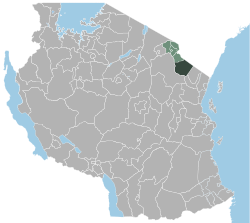
 Location of Same District in Tanzania |
|
| Basic data | |
| Country | Tanzania |
| region | Kilimanjaro |
| surface | 6221 km² |
| Residents | 269,807 (2012) |
| density | 43 inhabitants per km² |
| ISO 3166-2 | TZ-09 |
Coordinates: 4 ° 4 ′ S , 37 ° 44 ′ E
Same is one of the six districts of the Kilimanjaro region with the capital of the same name, Same . The district is bordered by the Mwanga District to the north, Kenya to the northeast, the Tanga region to the southeast, and the Manyara region to the south and west .
geography
The district has a size of 6221 square kilometers and around 270,000 inhabitants (as of 2012). The country is crossed from north to south by the Pare Mountains , which are up to 2,464 meters high. To the west lies the wide valley of the Pangani River . The plains in the east are drained by the Mkomazi River. It is broken through by individual hills and extends to the border with Kenya. Most of this area is part of the Mkomazi National Park . The climate in Same depends on the location, in the capital it is tropical. There are two rainy seasons, one in November and December and a second in March and April. The months June to September are very dry.
history
The district was established in 1984.
Administrative division
The district consists of 31 parishes (wards):
- Seed
- Ruvu
- Njoro
- Kisiwani
- Msindo
- Mshewa
- Mhezi
- Mwembe
- Vudee
- Vuje
- Bombo
- Mtii
- Maore
- Ndungu
- Kihurio
- Bendera
- Myamba
- Mpinji
- Bwambo
- Vunta
- Chome
- Suji
- Makanya
- Hedaru
- Kirangare
- Kisima
- Stesheni
- Vumari
- Mabilioni
- Kalemawe
- Lugulu
population
The largest ethnic group are the Pare . In 1988 the population was 169,718, the number rose to 211,738 in 2002 and 269,807 in 2012. In 2012, 71 percent of those over five spoke Swahili and 17 percent spoke English and Swahili. Twelve percent were illiterate.
Facilities and services
- Education: 192 primary schools are available in the district for the education of young people, seven of which are private and 185 public. Of the 51 secondary schools, 36 are public and 15 are private (as of 2019).
- Health: In Same there are two hospitals, eight health centers and 62 pharmacies (as of 2019).
- Water: In 2019, 70 percent of the rural population and 75 percent in the villages had access to safe and clean water.
Economy and Infrastructure
- Agriculture: The main crops are corn and rice. Where there are irrigation options, these are grown alternately. 70 percent of Tanzania's ginger production also comes from Same.
- Mining: In 2018, 29,000 tons of bauxite and 40,000 tons of gypsum were mined in Same.
- Railway: In the west of the Pare Mountains, the Usambara Railway runs through the district capital Same. It connects Tanga and Dar es Salaam in the south with Moshi and Arusha in the north.
- Roads: The main road connection is the national road T2, which crosses the district from south to north parallel to the Usambara line.
Attractions
- Mkomazi National Park: This 3245 square kilometer national park is located in the east of the district and extends south into the Tanga region. Together with the Tsavo West National Park in Kenya, it is a typical East African dry savannah. In addition to giraffes, eland, wildebeest, zebras, oryx, impalas, Thomson and Grant's gazelles, buffalo and numerous predators such as lions, leopards, hyenas and cheetahs, the park is also known for its more than 400 species of birds.
Web links
Individual evidence
- ↑ Tanzania: Administrative Division (Regions and Districts) - Population Statistics, Charts and Map. Retrieved April 2, 2020 .
- ^ A b Tanzania Regional Profiles, 03 Kilimanjaro Regional Profile. (PDF) The United Republic of Tanzania, 2016, p. 15 , accessed on April 2, 2020 .
- ↑ Maps for the World, Map 500k - xb37-1. Russian Army Maps, accessed April 2, 2020 (Russian).
- ↑ Same. Retrieved April 2, 2020 (de-US).
- ↑ Same climate: Average Temperature, weather by month, Same weather averages - Climate-Data.org. Retrieved April 2, 2020 .
- ↑ a b c History | Same District Council. Retrieved April 2, 2020 (Swahili).
- ↑ 2012 Population and Housing Census. (PDF) National Bureau of Statistics and Ministry of Finance, March 2013, p. 38 , accessed April 2, 2020 .
- ↑ Kilimanjaro Region Investment Guide. (PDF) 2017, p. 7 , accessed on April 2, 2020 .
- ↑ Tanzania Regional Profiles, 03 Kilimanjaro Regional Profiles. (PDF) The United Republic of Tanzania, 2016, p. 72 , accessed on April 2, 2020 .
- ↑ Takwimu / Statistics. Retrieved April 2, 2020 (Swahili).
- ↑ Kilimanjaro Region Investment Guide. (PDF) 2018, p. 8 , accessed on April 2, 2020 .
- ↑ Kilimanjaro Region Investment Guide. (PDF) 2018, p. 40 , accessed on April 2, 2020 .
- ↑ Kilimanjaro Region Investment Guide. (PDF) 2017, p. 58 , accessed on April 2, 2020 .
- ^ Tanzania Trunk Roads Network. Retrieved April 2, 2020 .
- ↑ Daniela Eiletz-chewing: Mkomazi National Park. In: Safari Insider. Accessed April 2, 2020 (German).


