Rota (island)
| rota | |
|---|---|
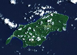
| Rota satellite image | |
| Waters | Pacific Ocean |
| Archipelago | Mariana Islands |
| Geographical location | 14 ° 9 ′ N , 145 ° 13 ′ E |
| length | 19 km |
| width | 8 kilometers |
| surface | 85.39 km² |
| Highest elevation | Mount Manira 495 m |
| Residents | 3283 (2000) 38 inhabitants / km² |
| main place | Songsong |
| Coast of Rota | |
Rota ( cham. Luta ) is next to Saipan and Tinian one of the three large islands of the US Commonwealth of the Northern Mariana Islands .
Rota is 58 km northeast of Guam and 90 km southwest of Tinian. The island is 19 km long, 8 km wide and has an area of 85.39 km² with a coastline of 61.6 km. The highest point is Mount Manira at 495 m above sea level.
The island had a population of 2,477 in the 2010 US census , the majority of which live in the Songsong settlement, which is also the largest. In the middle of the island is the airport with a 1800 m long runway.
Rota was part of the German colony of German New Guinea from 1899 to 1918 . On October 21, 1914, Rota was occupied by Japanese troops. In the Pacific War Rota was the strategy of island hopping otherwise not busy as the neighboring islands of Guam and Tinian by the American forces, so that the garrison of about 2,000 members of the Japanese Army Imperial and Marine consisted, until the surrender on September 2, 1945 remained on the island.
Web links
- Search for Island of Rota in the SPK digital portal of the Prussian Cultural Heritage Foundation
- Pascal Horst Lehne and Christoph Gäbler: About the Marianas. Lehne-Verlag, Wohldorf, 1972
Individual evidence
- ^ Hermann Joseph Hiery (ed.): The German South Seas 1884-1914 - A manual . 2nd edition, Paderborn / Munich / Vienna / Zurich: Ferdinand Schöningh, 2002, p. 829. ISBN 3-506-73912-3


