Agrigan
| Agrigan | |
|---|---|
| NASA satellite image of Agrigan | |
| Waters | Pacific Ocean |
| Archipelago | Mariana Islands |
| Geographical location | 18 ° 46 ′ 42 " N , 145 ° 40 ′ 17" E |
| length | 9 km |
| width | 6 km |
| surface | 43.51 km² |
| Highest elevation | Mount Agrigan 965 m |
| Residents | uninhabited |
| main place | Agrihan Village (evacuated in 1990) |
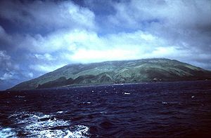
| Clouds over Agrihan, view from the south | |
The Agrigan , (other names: Agrihan , Agiguan , Aguigan , Agujan , Granger , Grigan , Francisco Xavier and St. Angel ) is a stratovolcano , which forms the island of the same name in the Pacific Ocean . Agrigan is geographically part of the Mariana Archipelago and politically part of the Commonwealth of the Northern Mariana Islands .
geography
At 965 meters, Agrigan is the highest volcano in the Mariana Islands . From the sea floor to the summit, the volcano has a total height of more than 4000 meters. The densely forested, elliptical island is over 9 kilometers long and up to six kilometers wide and has an area of around 44 km². The summit region forms a 500-meter-deep caldera that is about two kilometers long and one kilometer wide. The caldera floor shows some lava flows and two volcanic cones, which were probably formed during the only known eruption in April 1917. As a result of the eruption with a magnitude of four on the volcanic explosive index (VEI), a village on the southeast coast was evacuated.
history
From a European point of view, Agrigan was discovered by Gómez de Espinosa on June 11, 1522 and named Cyco or La Griega . Espinosa had taken part in the circumnavigation of the world under Ferdinand Magellan and after Magellan's death tried unsuccessfully to take the ship Trinidad through the Pacific to Mexico. Since the Chamorros who lived on the island behaved repellent, Espinosa could not anchor. He kidnapped a Chamorro to use as an informant. In 1669 the Spanish missionary Diego Luis de Sanvitores visited Agrigan. The islanders were deported to Saipan Island in 1695 and to Guam three years later .
In 1810, when Agrigan was a Spanish colony , settlers from Hawaii and the United States tried to plant plantations on the island, but were expelled. From the 1850s, the island was leased to companies. The first coconut plantations were established in the 1870s. Around 1880 Adolph Capelle, a merchant from Braunschweig , was the leaseholder of the island. He exported copra and employed about 20 seasonal workers on the island, who came from the Caroline Islands and had their main residence on the islands of Saipan or Guam.
After the Northern Mariana Islands were sold to the German Empire in 1899, Agrigan was part of the German New Guinea colony until 1914 . During this time the island was leased to the Pagan Society , who planted more coconut plantations. When the German district administrator Georg Fritz visited the island in May 1901, 32 people lived in the 15 huts of a workers' settlement in the southwest of the island. 100 tons of copra were extracted annually. In September 1905 and September 1907, severe typhoons almost completely destroyed the coconut plantations. According to estimates from 1912, Agrigan had 162 hectares of coconut plantation; However, due to a lack of capital, the Pagan Society could not systematically manage the plantations.
Between 1919 and 1944, Agrigan was administered by Japan as part of the South Seas Mandate . From 1947 the island was part of the United States Pacific Islands Trust Territory ; since 1978 to the Commonwealth of the Northern Mariana Islands . In 1967, 94 people are said to have lived on Agrigan.
After a report of increased active fumaroles , the nine islanders were evacuated in August 1990, as a volcanic eruption was feared. Investigations carried out in 1990 and 1992 did not reveal any evidence of increased activity in the volcano. There were 25 solfataras and a boiling hot spring in the caldera ; in addition, steam escaped in several places. In 2000 six people lived in one of the original four settlements on the island. According to the 2010 census, the island was uninhabited.
literature
- Russell E. Brainard et al .: Coral reef ecosystem monitoring report of the Mariana Archipelago: 2003-2007. (= PIFSC Special Publication , SP-12-01) NOAA Fisheries, Pacific Islands Fisheries Science Center 2012 ( Chapter Maug (English, PDF, 21.9 MB)).
Web links
- Pascal Horst Lehne, Christoph Gäbler: About the Marianas. Lehne-Verlag, Wohldorf 1972.
- Agrihan the Global Volcanism Program of the Smithsonian Institution (English)
- Agrigan at the Pacific Islands Benthic Habitat Mapping Center (PIBHMC) of the University of Hawaiʻi at Mānoa (English)
- Agrigan on Peakbagger.com (English)
Individual evidence
- ↑ entry agrihan in German colonial lexicon , Volume I, p. 25
- ^ Agrigan - Eruptive History in the Global Volcanism Program (accessed December 19, 2012).
- ^ Robert F. Rogers: Destiny's landfall. A history of Guam. University of Hawai'i Press, Honolulu 1995, ISBN 0-8248-1678-1 , p. 10.
- ↑ a b Brainard, Coral reef ecosystem monitoring report , p. 2 (English, PDF, 21.9 MB).
- ↑ Gerd Hardach: King Copra. The Mariana Islands under German rule 1899–1914. Steiner, Stuttgart 1990, ISBN 3-515-05762-5 , pp. 23f, 32, 46.
- ^ Georg Fritz: Journey to the northern Marianas. In: Communications from explorers and scholars from the German protected areas , 1902 (15), pp. 96–118, here p. 110 (pdf, 3.7 MB).
- ↑ Hardach, König Kopra , pp. 124, 135-137.
- ↑ Pascal Horst Lehne, Christoph Gäbler: About the Marianas. (Accessed January 9, 2013).
- ↑ Monthly Reports to the Global Volcanism Program (accessed December 19, 2012).


