Rudbøl
|
Rudbøl ( German Ruttebüll ) |
||||
|
||||
| Basic data | ||||
|---|---|---|---|---|
| State : |
|
|||
| Region : | Syddanmark | |||
|
Municipality (since 2007) : |
Tønder | |||
| Municipality / Office : (until the end of 2006) |
Tønder Kommune Sønderjyllands Amt |
|||
|
Harde / Amt: (until March 1970) |
Tønder, Højer og Lø Herred Herred Tønder Amt |
|||
| Sogn : | Højer | |||
| Coordinates : | 54 ° 54 ' N , 8 ° 45' E | |||
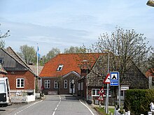
 Rudbøl from the bridge over the Vidå seen from |
||||
Rudbøl ( German Ruttebüll ) is located in the Danish Sønderjylland , the southern part of the Jutian peninsula , and is a small village in Højer Sogn on the Danish / German border . The place is in the Tønder municipality and belongs to the region Syddanmark .
history
When the province of Schleswig-Holstein was divided between Denmark and Germany after the referendum in Schleswig in 1920, the new border ran through Rudbøl and divided the place into a Danish and a German part.
In Rudbøl is the boundary stone no. 245. This is in the middle of the road that leads from Germany to Denmark. To the west of the road is the Danish side of the border, to the east the German side.
Rudbøl originally had three inns, two of which are still in operation. The Grænsekro inn has existed in the village since 1711 , and has bought some houses and rents them out as holiday apartments. There is a campsite next to the inn . There is also a youth hostel in Rudbøl . On today's German side there is the former Rosenkranz Kro , which is now called Alter Deutscher Grenzkrug and is located in the Rosenkranz part of the Aventoft community .
location
Rudbøl is located in the Tøndermarsch ( Danish Tøndermarsken ), which is Denmark's largest contiguous meadow area with around 2500 hectares, and on the north-western shore of the Ruttebüller See ( Danish Rudbøl Sø ), which is divided by the Danish-German border. Rudbøl is one of the few villages in Denmark that was built on a dike .
Web links
- Tøndermarsken. Kort over Marskstien. In: toendermarsken.dk. Retrieved June 22, 2020 (Danish).
- Højer Mølle. Port to Tøndermarsken and Vadehavet National Park. MUSEUM SØNDERJYLLAND, accessed November 20, 2019 (Danish).

