Rungna Bridge
Coordinates: 39 ° 2 ′ 2 ″ N , 125 ° 45 ′ 54 ″ E
| Rungna Bridge | ||
|---|---|---|
| Rungna Bridge | ||
| Official name |
Hangeul : 릉 라교 ( 능라 교 ) Hanja : 綾 羅 橋 Revised Romanization : Reungragyo (Neungragyo) McCune-Reischauer : Rŭngragyo (Nŭngragyo) (South Korean spelling in brackets) |
|
| use | Road traffic | |
| Convicted | At Sang Teak Street / Kumnung Tunnel | |
| Crossing of | Taedong gang | |
| place | Pyongyang , Chung-guyŏk District , Taedonggang-guyŏk | |
| construction | Girder bridge | |
| overall length | 1070 m | |
| completion | 1988 | |
| location | ||
|
|
||
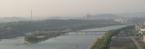
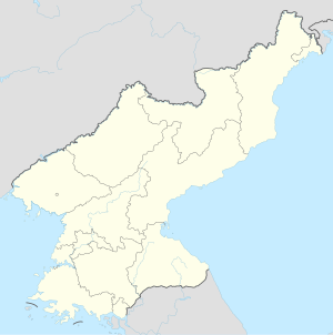
The Rungna Bridge (also Rungra Bridge ) is a road bridge in the North Korean capital, Pyongyang . It connects the western part of Puksae in the Chung-guyŏk district via An-Sang-Thaek Street with the eastern part of Munsu in the Taedonggang-guyŏk district with an overpass over the island of Rungna and is one of the six bridges that cross the Taedong in Pyongyang -gang lead.
history
In city plans from 1930 and 1946, a bridge is already drawn in at the site of the current bridge, which leads from the west bank of the river to the island, but not further to the east bank.
The construction of the 1070 meter long girder bridge began in 1986. It was completed and opened to traffic in September 1988.
Others
A motif of the bridge is shown on the back of the 500 won notes from 1998.
Web links
Individual evidence
- ↑ a b Philipp Meuser (ed.): Architectural Guide Pyongyang. Volume 1: Photos and Descriptions. DOM publishers, Berlin 2011, ISBN 978-3-86922-126-7 , p. 102.
- ^ Philipp Meuser (Ed.): Architectural Guide Pyongyang. Volume 2: Background and Comments. DOM publishers, Berlin 2011, ISBN 978-3-86922-126-7 , p. 88.
- ↑ Rungna Bridge. In: Structurae de.structurae.de


