Taedonggang-guyŏk
| Taedonggang-guyŏk
|
|
|---|---|
| Chosŏn'gŭl : | 대동강 구역 |
| Hancha : | 大同 江 區域 |
| McCune-Reischauer : | Taedonggang-guyŏk |
| Revised Romanization : | Daedonggang-guyeok |
| Basic data | |
| Surface: |
km²
|
| Structure : |
15 dongs |
| Administrative headquarters : | Pyongyang |
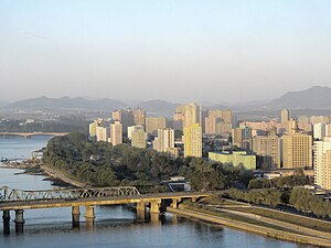
Taedonggang-guyŏk is one of the 18 boroughs of Pyongyang , the capital of North Korea . The district borders Tongdaewŏn-guyŏk in the south . The Taedong-gang forms the border with the inner city district of Chung-guyŏk . There are several diplomatic representations from other countries in Taedonggang-guyŏk.
The Ongnyu Bridge , the rungra Bridge and the Chongnyu bridge connecting the district with the north of the Taedong River town of the area and the island rungra .
history
Taedonggang-guyŏk originally formed the district of East Pyongyang. During the time of Japanese rule, there was an airport in the district, which covered about half the area of the current district. In 1958 it was established as today's district of Pyongyang.
Buildings and facilities
In the district of Tongmun-dong is the monument to the founding of the Labor Party of Korea, which was erected in 1995 and is intended to commemorate the founding of the Labor Party of Korea in 1945.
The medical facilities in the district include Kim Man Yu Hospital and Pyongyang Maternity Hospital on Sanwon Street. The ten research institutes of the National Academy and Institute of Koryo Medicine focus on holistic medicine .
On the banks of the Taedong-gang in the north of the district, the Munsu water amusement park is located on an area of 240,000 square meters and can accommodate up to 8,000 visitors a day. In the south of the district, Sanwon Park serves as a local recreation area.
Diplomatic missions
Taedonggang-guyŏk is the location of several diplomatic missions. Most of the embassies are in the districts of Munsu-dong and Muhung-dong. For children of the diplomatic staff, a special school for foreigners has been set up, which is not based on North Korea's curricula.
education
There are several universities and educational institutions in Taedonggang-guyŏk. Pyongyang University of Mechanical Engineering is one of the older ones . The university, which specializes in mechanical engineering, was founded in September 1959 and has 19 faculties and around 50 chairs.
The Pyongyang University of Music and Dance has existed since 1972 and was the result of a merger of the Pyongyang Dance College and the Pyongyang College of Art. In addition, there is another music college in Taedonggang-guyŏk, the Pyongyang Kim Won Gyun Conservatory . It has existed since 2006 and is named after the North Korean composer Kim Won Gyun .
The Korean School for Foreigners has been specially set up for children of foreign nationals and diplomats living permanently in North Korea. The curriculum is based on Western educational institutions and does not use the ideological influence of the Democratic People's Republic of Korea.
The University of International Studies is a university for employees of the North Korean state apparatus who are or should be employed abroad. It is subordinate to both the Ministry of Education and the Ministry of Foreign Affairs.
The University of Economics and the Military Medical College for Military Medicine are also located in the district.
Administrative division
Taedonggang-guyŏk is divided into twelve administrative units, the dongs . The districts Soryong-dong, Sagok-dong and Rungra-dong are in turn divided into two, the districts Tapche-dong, Munsu-dong, Okryu-dong and Chongryu-dong into three administrative units.
| Chosŏn'gŭl | Hancha | |
|---|---|---|
| Chongryu-dong | 청류 동 | 淸 流 洞 |
| Munhung-dong | 문흥동 | 文 興 洞 |
| Munsu-dong | 문수동 | 紋繡 洞 |
| Okryu-dong | 옥류동 | 玉 流 洞 |
| Puksu-dong | 북수동 | 北 繡 洞 |
| Rungra-dong | 릉 라동 | 綾 羅 洞 |
| Sagok-dong | 사곡동 | 四 谷 洞 |
| Soryong-dong | 소룡동 | 小 龍洞 |
| Taedonggang-dong | 대동 강동 | 大 洞 江 洞 |
| Tapche-dong | 탑제 동 | |
| Tongmun-dong | 동문동 | 東門 洞 |
| Uiam-dong | 의암 동 | 衣 岩洞 |
Web links
Individual evidence
- ^ Map from 1946
- ↑ 북한 지명 사전 . joins.com. Retrieved May 16, 2013.
Coordinates: 39 ° 2 ' N , 125 ° 47' E

