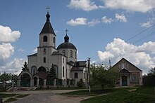
Ruska Losowa
| Ruska Losowa | ||
| Руська Лозова | ||

|
|
|
| Basic data | ||
|---|---|---|
| Oblast : | Kharkiv Oblast | |
| Rajon : | Derhatschi Raion | |
| Height : | 148 m | |
| Area : | 3.859 km² | |
| Residents : | 5,018 (2004) | |
| Population density : | 1,300 inhabitants per km² | |
| Postcodes : | 62332 | |
| Area code : | +380 5763 | |
| Geographic location : | 50 ° 8 ' N , 36 ° 17' E | |
| KOATUU : | 6322082001 | |
| Administrative structure : | 1 village, 2 settlements | |
| Address: | вул. Лермонтова 7 62332 с. Руська Лозова |
|
| Website : | City council website | |
| Statistical information | ||
|
|
||
Ruska Losowa ( Ukrainian Руська Лозова ; Russian Русская Лозовая Russkaja Losowaja ) is a village in the north of the Ukrainian Oblast Kharkiv with about 5000 inhabitants (2004).
The village, surrounded by deciduous forests, was founded in 1647 and is the administrative center of the 82.66 km² district council of the same name in the east of Derhatschi Rajon , to which the settlements Nowe ( Нове , ⊙ ), until 2013 a village with about 70 inhabitants and Pytomnyk ( Питомник , ⊙ ) with about 200 inhabitants.
Ruska Losowa is located on the M 20 / E 105 highway, 20 km north of the center of Kharkiv and 18 km east of the Derhatschi district center . The border with Russia runs north about 20 kilometers away.
Web links
Commons : Ruska Losowa - collection of pictures, videos and audio files
Individual evidence
- ↑ The village's website on the Verkhovna Rada website , accessed on October 30, 2015
- ↑ http://w1.c1.rada.gov.ua/pls/z7503/A005?rf7571=43380


