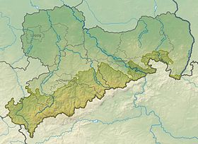
Saxon uplands and low mountain ranges
| Natural regions in Saxony | |
|---|---|
| Systematics according to | Natural areas and natural area potentials of the Free State of Saxony |
| Natural region | Saxon uplands and low mountain ranges |
| Geographical location | |
| Coordinates | 51 ° 0 ′ 0 ″ N , 13 ° 0 ′ 0 ″ E |
| The natural region of Saxon Uplands and Central Uplands | |
| state | Saxony |
| Country | Germany |
A natural region in Saxony is referred to as the Saxon Uplands and Central Uplands . The systematics of the natural areas in Saxony groups the natural spatial units of the upper choral dimension level ( macrogeochores ) into three Saxon natural regions in order to clarify their classification on a regional scale.
The Saxon Uplands and Uplands is part of the Central European Uplands Threshold , which continues west in the Thuringian-Franconian Uplands and east in the Sudetes . The natural region takes up about a third of the area of the Free State of Saxony. Their demarcation was drawn in the southwest, southeast and east congruent with the Saxon state or German state border, since the underlying natural space coverage was limited to the territory of Saxony, but the physiogeographical characteristics of the macrogeochores each extend somewhat beyond this arbitrary mapping boundary. Only in the north does the edge of the closed distribution of the loess soils form a defined natural boundary that separates the Saxon mountainous and low mountain range from the natural region of Saxon loess .
features
The mosaic of the natural areas in the Saxon uplands and low mountain ranges is more heterogeneous than that of the other natural regions of Saxony. The connecting features are the geomorphological structure , which is fundamentally shaped by the Saxon clod tectonics and subsequent erosion and sedimentation processes, as well as the soils, which are predominantly formed from Quaternary weathering layers .
Natural structure
The following macro geochores are currently assigned to the Saxon Uplands and Central Uplands (for a detailed breakdown into meso- and microgeochores, see the list of natural units in Saxony ):
- Vogtland
- Elster Mountains
- Western Ore Mountains
- Middle Ore Mountains
- Eastern Ore Mountains
- Saxon Switzerland
- Upper Lusatian highlands
- Zittau Mountains
The Federal Agency for Nature Conservation used until the recent past nor the outline design of the Handbook of the Natural Region Divisions of Germany from the 1950s ( main unit groups and main units in brackets the approximate location within the newer classification):
- 41 VOGTLAND
- 410 East Thuringian-Vogtland plateaus
- 411 Central Vogtland hill country
- 412 Upper Vogtland
- Elster Mountains
- 42 ORE MOUNTAINS
- 420 southern slope of the Ore (extreme southwest of the West Erzgebirge )
- 421 Upper Westerzgebirge ( Westerzgebirge up to the extreme southwest and far north-east, south of the Middle Erzgebirge )
- 422 Upper Eastern Ore Mountains (south of the Eastern Ore Mountains )
- 423 Lower Western Ore Mountains (extreme northeast of the Western Ore Mountains , north and center of the Central Ore Mountains )
- 424 Lower Eastern Ore Mountains (north and middle of the Eastern Ore Mountains )
- 43 SAXON-BOHEMIAN CHALK SANDSTONE REGION
- 430 Saxon Switzerland
- 431 Zittau Mountains
- 44 OBERLAUSITZ
- 441 Upper Lusatian highlands
See also
swell
- Mannsfeld, K .; Bastian, O .; Kaminski, A .; Katzschner, W .; Röder, M .; Syrbe, R.-U .; Winkler, B. (2005): Landscapes in Saxony. Messages of the Landesverein Sächsischer Heimatschutz eV, special issue, without ISBN.
- Mannsfeld, K. and Syrbe, R.-U. (Ed.): Natural spaces in Saxony with a map supplement “Naturräumliche Gliederung Sachsens”, in: Research on German regional studies (Volume 257), German Academy for Regional Studies, self-published, Leipzig, 2008, ISBN 978-3-88143-078-4
- Mannsfeld, K .; Bastian, O .; Bieler, J .; Gerber, S .; King, A .; Lütz, M .; Schulze, S .; Syrbe, R.-U .: Final report of the work unit "Natural balance and regional character" 1965-2007
- Landschaftsforschungszentrum eV Dresden: Research system for the natural spaces and natural space potentials of the Free State of Saxony (map view of the natural regions: in the “Subjects” tab, expand the “Natural spaces” folder, activate the “Natural regions” checkbox)
- Saxon State Ministry for Environment and Agriculture (Ed.): Nature reserves in Saxony. Central brochure dispatch of the Saxon State Government, Dresden 2008, ISBN 3-932627-17-2
Web links
-
Federal Agency for Nature Conservation , map services
- Landscape profiles
- Vogtland
- High elevations of the East Thuringian-Vogtland plateau and the Central Vogtland hill country
- Upper Saale Valley
- Northern East Thuringian-Vogtland plateaus (without pond plate)
- Plothener pond plate
- Ronneburg arable and mining area (northeastern East Thuringian-Vogtland plateau)
- Lower layers of the Central Vogtland hill country
- Middle-high areas of the Upper Vogtland
- Lower layers of the Upper Vogtland
- Ore Mountains
- Southern roofing of the Ore Mountains
- Upper layers on the northern roof of the West and Central Ore Mountains
- Lower layers of the Western Ore Mountains
- Lower layers of the Middle Ore Mountains
- Upper layers of the Osterzgebirge
- Lower layers of the Osterzgebirge
- Tharandt Forest (in the north of the Osterzgebirge)
- Chalk sandstone area and Upper Lusatia
- Saxon Switzerland (without Elbe Valley)
- Upper Elbe Valley
- Upper Lusatian highlands
- Zittau Mountains
- Vogtland
- Landscape profiles
