
Sèvres - Babylone (Métro Paris)
|
|
|
|---|---|

|
|
| Tariff zone | 1 |
| Line (s) |
|
| place | Paris VI , Paris VII |
| opening | November 5, 1910 |


Sèvres - Babylone is an underground transfer station of the Paris Métro . It is served by lines 10 and 12 .
location
The metro station is located on the border of the Notre-Dame-des-Champs district of the 6th arrondissement and the Saint-Thomas-d'Aquin district of the 7th arrondissement of Paris .
Surname
The station takes its name from Rue de Sèvres, under which the station of line 10 is located. Sèvres is a south-western suburb of Paris in the Hauts-de-Seine department . The rue de Babylone branching off from it contributes the second part of the name . The ruins of the ancient city of Babylon are in what is now Iraq . In 1638 Jean Duval, who owned several buildings on Rue de Grenelle, became Bishop of Babylon as Bernard de Sainte Thérèse . In 1810 the rue de Grenelle is already mentioned as rue de Babylone.
Until the opening of the line 10 station in 1923, the subway station was called "Sèvres" or "Sèvres-Croix Rouge".
history
The subway station went into operation on November 5, 1910 with the opening of Line A of the Société du chemin de fer électrique souterrain Nord-Sud de Paris (North-Sud). The first section ran from the Porte de Versailles station to the Notre-Dame-de-Lorette station . On December 30, 1923, the line 10 station of the Compagnie du chemin de fer métropolitain de Paris (CMP) was opened under the name "Babylone". Shortly afterwards, both stations were connected and were given the current name. In 1930, the north-south routes were taken over by the CMP, and the former route A became route 12 on March 27, 1931.
description
Both stations are under elliptically vaulted ceilings and each have two side platforms on two main tracks. The station of line 10 is below the Rue de Sèvres, west of the Boulevard Raspail . Your route passes under the line 12 almost at right angles. The station for line 12 is located lengthways under Boulevard Raspail north of Rue de Sèvres. Typically for the underground stations in the north-south, it was built somewhat more splendidly than the stations of the CMP, and it is slightly higher because of the original overhead line . While the side walls of the CMP design follow the curvature of the ellipse, the walls of the north-south station run vertically in the lower area. There are no connecting tracks between the two lines.
Depending on the line, the original part of the name on the station signs is written larger than the addition: "Sèvres" in the station on line 12 and "Babylone" on line 10.
There are three entrances and exits, including two with escalators.
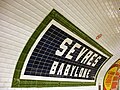
Station sign for line 12, emphasis on the part of the name "Sèvres"

The station signs on line 10 emphasize the second part of the name
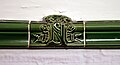
Faience with emblem of the north-south in the station of the former line A.


vehicles
Conventional trains of the MF 67 series run on both lines , since 1977 on line 12. Its predecessor was the Sprague-Thomson type , with the leading railcars of the trains used by the north-south getting their power from an overhead line. Between 1975 and 1994, 10 trains of the MA series ran on the line .
Web links
literature
- Gérard Roland: Stations de métro. D'Abbesses à Wagram . 2003, ISBN 2-86253-307-6 .
Individual evidence
- ^ Jean Tricoire: Un siècle de métro en 14 lignes. De Bienvenüe à Météor . 2nd Edition. La Vie du Rail, Paris 2000, ISBN 2-902808-87-9 , p. 277 .
- ↑ Rue de Babylone at: Le Paris pittoresque, accessed on March 29, 2016.
- ^ Gérard Roland: Stations de métro d'Abbesses à Wagram . Christine Bonneton, Clermont-Ferrand 2011, ISBN 978-2-86253-382-7 , pp. 199 .
- ↑ Jean Tricoire op. Cit. P. 295.
- ↑ Jean Tricoire op. Cit. P. 273.
| Previous station | Paris metro | Next station |
|---|---|---|
|
Vaneau ← Boulogne - Pont de Saint-Cloud |
|
Mabillon Gare d'Austerlitz → |
|
Rue du Bac ← Front Populaire |
|
Rennes Mairie d'Issy → |
Coordinates: 48 ° 51 ′ 5 ″ N , 2 ° 19 ′ 36 ″ E