Sølyst
| Sølyst | ||
|---|---|---|
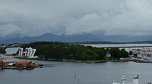
| View from the southwest, 2017 | ||
| Waters | Byfjord and Pinå | |
| Geographical location | 58 ° 58 '40 " N , 5 ° 44' 35" E | |
|
|
||
| length | 650 m | |
| width | 300 m | |
Sølyst is an island in the North Sea off the Norwegian city of Stavanger in the province of Rogaland .
It is located northeast of the port of Vågen in the north of the city. Immediately to the south is the island of Grasholmen , north of Engøy . To the west of it are the small archipelago islands of Plentingen and Natvigs Minde .
From the city center to the south, the Stavanger bybru, completed in 1978, leads over Grasholmen to Sølyst. The road connection continues north near the eastern end of the island, and then the Engøybrua spans the Engøysundet to the island of Engøy. A small bridge also connects Sølyst directly with Grasholmen.
Sølyst extends from southwest to northeast for about 650 meters with a width of up to about 300 meters. It reaches a height of 29.5 meters and is partially forested. The southern shore of the island is dominated by a large marina .
From 1925 the shipping company Det Stavangerske Dampskibsselskab operated a coal storage facility on the north side of the island.
In 2017, the island became the location for various works of art in public space as part of a cultural project.

