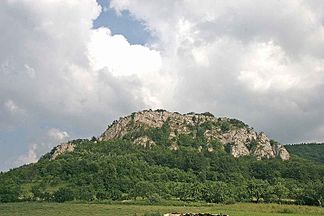
Súľovské vrchy
| Súľovské vrchy | ||
|---|---|---|
|
Bosmany natural monument near Kostolec |
||
| Highest peak | Veľký Manín ( 891 m nm ) | |
| location | Slovakia | |
|
|
||
| Coordinates | 49 ° 10 ′ N , 18 ° 35 ′ E | |
| rock | Conglomerate, limestone, dolomite | |

The Súľovské vrchy (slow. Plural, German about "heights of Súľov") is a small mountain range in northwestern Slovakia , about between the cities of Považská Bystrica , Rajec and Žilina , between the valleys of the Waag west and the Rajčanka east of the mountains. The mountain is named after the village of Súľov, today part of the municipality of Súľov-Hradná . It is under protection as part of the Strážovské vrchy Protected Landscape Area .
The Súľovské vrchy is divided into three sub-units:
- Skalky
- Súľovské skaly (roughly "Rock of Súľov")
- Manínska vrchovina (roughly "Manín Hills")
The highest mountain is Veľký Manín with 891 m nm , some other mountains are the Žibrid ( 867 m nm ), Havrania skala ( 835 m nm ), Kečka ( 822 m nm ) and Skalky ( 778 m nm ).
In the southern part near Záskalie you can find the Manínska tiesňava and Kostolecká tiesňava gorges formed by the Manínsky potok . In the central part northwest of Súľov, the Súľovské skaly form a structure of bizarre and pointed rock formations ( rock needles , cliffs , rock openings, etc.). The ruins of the castles Hričov , Lietava and Súľov are interesting from a architectural point of view .
literature
- Kopa, Ľudovít et al .: The Encyclopaedia of Slovakia and the Slovaks . Encyclopedia Institute of the Slovak Academy of Sciences, Bratislava 2006, ISBN 80-224-0925-1 , p. 667 (keyword Súľovské vrchy ).
Web links
- Tourism across the mountains (English)


