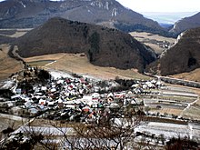
Kostolec
| Kostolec | ||
|---|---|---|
| coat of arms | map | |

|
|
|
| Basic data | ||
| State : | Slovakia | |
| Kraj : | Trenčiansky kraj | |
| Okres : | Považská Bystrica | |
| Region : | Severné Považie | |
| Area : | 4.001 km² | |
| Residents : | 242 (Dec. 31, 2019) | |
| Population density : | 60 inhabitants per km² | |
| Height : | 495 m nm | |
| Postal code : | 017 05 ( Považská Bystrica post office ) | |
| Telephone code : | 0 42 | |
| Geographic location : | 49 ° 8 ' N , 18 ° 32' E | |
| License plate : | PB | |
| Kód obce : | 513245 | |
| structure | ||
| Community type : | local community | |
| Administration (as of November 2018) | ||
| Mayor : | Miroslav Michalík | |
| Address: | Obecný úrad Kostolec č. 193 017 05 Považská Bystrica |
|
| Website: | www.kostolec.sk | |
| Statistics information on statistics.sk | ||
Kostolec (until 1946 in Slovak "Kostelec"; in Hungarian Kosfalu - until 1907 Kosztelec ) is a municipality in northwestern Slovakia with 242 inhabitants (as of December 31, 2019) and belongs to the Okres Považská Bystrica , a district of the Trenčiansky kraj .
geography
The village is located in the Súľovské vrchy mountains in the valley of the Manínsky brook . The route to and from Záskalie passes through the narrow Kostolecká tiesňava gorge , which has been a nature reserve since 1970. To the east of the main town rises the three-tower rock formation Bosmany , a natural monument since 1994. The center of the village lies at an altitude of 495 m nm and is ten kilometers from Považská Bystrica .
Neighboring municipalities are Plevník-Drienové in the north, Vrchteplá in the east, Bodiná in the southwest, Považská Bystrica (districts Pražnov and Podmanín ) in the south and Záskalie in the west.
history
Kostolec was first mentioned in writing as Kostolech in 1430 . The village was owned by the noble Černak families and from the 15th century belonged to the territory of Waagbistritz. In 1784 the village had 27 houses, 26 families and 170 inhabitants, in 1828 there were 23 houses and 209 inhabitants who were employed as farmers.
Until 1918 the place in Trenčín County belonged to the Kingdom of Hungary and then came to Czechoslovakia or now Slovakia.
population
According to the 2011 census, there were 238 residents in Kostolec, including 236 Slovaks and one Czech . One resident gave no information about ethnicity .
196 residents committed to the Roman Catholic Church, 25 residents to the Evangelical Church AB and one resident to the Evangelical Methodist Church. Ten residents were non-denominational and six residents had no denomination.
Individual evidence
- ↑ Slovenské slovníky: názvy obcí Slovenskej republiky (Majtán 1998)
- ↑ Prírodná rezervácia Kostolecká tiesňava. Štátny zoznam osobitne chránených častí prírody SR, accessed on April 26, 2020 .
- ↑ Prírodná pamiatka Bosmany. Štátny zoznam osobitne chránených častí prírody SR, accessed on April 26, 2020 .
- ↑ Results of the 2011 census (Slovak)
Web links
- Entry on e-obce.sk (Slovak)


