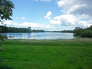
Südensee
| Südensee | ||
|---|---|---|

|
||
| Geographical location | Municipality of Sörup , Schleswig-Flensburg District , Schleswig-Holstein , Germany | |
| Drain | Südensee-Au → Bondenau | |
| Places on the shore | Soerup | |
| Location close to the shore | Flensburg | |
| Data | ||
| Coordinates | 54 ° 42 '27 " N , 9 ° 39' 14" E | |
|
|
||
| Altitude above sea level | 30.48 m above sea level NN | |
| surface | 63.4 ha | |
| length | 2 km | |
| width | 500 m | |
| volume | 1,430,000 m³ | |
| scope | 5.1 km | |
| Maximum depth | 3.6 m | |
| Middle deep | 2.26 m | |
| Catchment area | 14.13 km² | |
The Südensee (Danish: Søndersø ) is a lake near Sörup in the Schleswig-Holstein district of Schleswig-Flensburg . The lime-rich , non-stratified lowland lake is about 30.5 meters above sea level , is 63.4 hectares in size, up to 3.6 meters deep and drains an area of 14.13 km². It can therefore be classified as a type 11 lake (calcareous, unstratified lowland lake with a relatively large catchment area and a residence time greater than 30 days) according to the lake typology by Mathes et al. (2002).
Location and origin
At the northeastern end of the lake (between its main tributaries) is the village of Sörup, south of the lake is the district of Südensee. At the southwestern end, the Südensee-Au drains the lake to Bondenau , the source river of the Treene . Together with the Sankelmarker See , the Rüder See , the Treßsee , the Winderatter See and the Havetofter See, it is part of the so-called North Angelite Lake Group . These lakes were created as a result of a glacial drainage channel after the last ice age .
The only bathing area is on the northeast bank in the village of Sörup, where there is also a playground and a mobile home area.
See also
Individual evidence
- ↑ a b c d e f g h Ministry for Agriculture, Environment and Rural Areas Schleswig-Holstein: Agriculture and Environment Portal: Südensee , accessed on April 15, 2011.
- ↑ J. Mathes, G. Plambeck, J. Schaumburg: The typing system for standing waters in Germany with water areas from 0.5 km² to implement the Water Framework Directive. In: B. Nixdorf, R. Deneke (Hrsg.): Approaches and problems in the implementation of the EU Water Framework Directive. Current series BTU Cottbus 2002, special issue: 15-24.
- ↑ Federal Environment Agency: Lake Typology in Germany ( Memento from September 9, 2013 in the Internet Archive ) (accessed on December 29, 2011)
- ↑ Lake assessment in Schleswig-Holstein, State Office for Nature and Environment of the State of Schleswig-Holstein (accessed on June 2, 2012; PDF; 12.7 MB)

