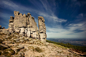
Słonecznik (Giant Mountains)
| Słonecznik German Mittagstein , Czech Polední kámen |
|
|---|---|
| Basic geotopic data | |
| Geotope type | Granite outcrop |
| Terrain height | 1423 m |
| Size (L × W × H) | L x W x 12 m |
| location | Lower Silesia , Poland |
| Geological unit (s) | Silesian ridge → Giant Mountains |
| Municipality / city | Podgórzyn ( Giersdorf ) |
| Coordinates | 50 ° 45 '35 " N , 15 ° 40' 59.8" E |
Słonecznik (German Mittagstein , Czech Polední kámen ) is the Polish name of a granite rock formation in the eastern part of the Silesian Ridge of the Giant Mountains in Poland .
location
The 12 meter high sunflower , as the literal translation into German, is located at an altitude of 1423 meters above sea level on the northern slope of the Smogornia (German Mittagsberg , Czech Stříbrný hřbet ), northwest of the Karkessel des Wielki Staw (German Great Pond ), in the district the municipality of Podgórzyn .
Emergence
The natural monument consists of several strongly jagged rock needles , of which the northern one, viewed from the eastern side, resembles a human figure. It emerged from a rock outcrop and a complex and long process of erosion . Decisive for the fantastic shapes of the rocks is the wool sack weathering that is characteristic of the Giant Mountains . Repeated freezing and thawing of the water between the cracks in the rock resulted in ever wider cracks in the rock , until the rock broke off and the needles finally stopped.
Names and legends
The rock group got its name due to the fact that the sun is overhead at noon when viewed from Podgórzyn, Przesieka and Borowice.
Their shape and peculiarity gave rise to many legends. Even today it is said that Rübezahl once wanted to drown Silesia. To do this, he decided to throw boulders into the pond to make it overflow. But the devil wanted to thwart this plan and acted as if he wanted to participate in this shameful act. But when he missed the angelus , he was petrified at sunrise. This is why the rock is also called "Teufelsstein".
A variation describes how Rübezahl dragged a large stone on a chain. Here, too, he had the intention of throwing it into the large pond and killing many people with the tidal wave that was triggered. Then he meets an old woman who pityed him and advised him to rest if the burden was too heavy for him. She'll help him get up again. He took the advice and rested. But when he wanted to pick up the stone again, he could no longer and had to leave the stone lying there. This is the midday stone on which you can still see the ring to which the chain was attached. So Silesia was spared a great misfortune. The old woman, some believe, was Our Lady.
According to another legend, the abode of the mountain spirit Rübezahl is itself in the rocks. The first map of the Giant Mountains was created by the Trautenau painter and chronicler Simon Hüttel , probably between 1576 and 1585. It shows a representation of Rübezahl at Mittagstein, in the form similar to that of Martin Helwig . The place on the map is called the "Rubenzagel Nest".
Tourism and nature protection
The Mittagstein is the most striking rock formation in the Giant Mountains, which can be seen from almost everywhere in the Hirschberg Valley and is one of the most visited rocks in the Giant Mountains. Here you have a beautiful view of the eastern and northeastern part of the Giant Mountains with the Pielgrzymy rock group in the foreground to the north or a view of the Polana mountain meadow in an easterly direction. The area belongs to the Polish national park Karkonoski Park Narodowy (KPN), so strict nature protection regulations apply. Picking and digging up plants and disturbing wildlife is a criminal offense. It is also forbidden to leave the hiking trails.
- A green marked path leads from the Spindlerpass ( Przełęcz Karkonoska in Polish , Slezské sedlo in Czech ) coming here.
- Marked in yellow, a path leads from Szklarska Poręba through the two districts of Podgórzyn Przesieka (German Hain ) and Borowice (German Baberhäuser ) around the sunflower to Polana (1067 meters), a clearing where the Schlingel-Baude stood, which in the December 1966 was destroyed by fire.


