
Smogornia
| Smogornia
Midday Mountain
|
||
|---|---|---|
 Spindlerpass , small balaclava , in the background the Mittagsberg. On the far left in the picture the Spindler's hut. |
||
| height | 1490 m | |
| location | Sudeten | |
| Mountains | Giant Mountains | |
| Coordinates | 50 ° 45 ′ 18 " N , 15 ° 40 ′ 35" E | |
|
||
| rock | granite | |

The Smogornia ( Mittagsberg , Czech. Stříbrný hřbet ) is a mountain in the eastern part of the main ridge of the Giant Mountains. It lies on the Czech-Polish border, about 6 km northeast of Spindleruv Mlyn (Czech Špindlerův Mlýn , Polish Szpindlerowy Młyn ) and 6 km west-southwest of Karpacz ( Krummhübel ).
With a height of 1490 meters above sea level , it is the sixth highest one-thousanders in the Czech Republic .
location

The slopes of the Smogornia are not very steep except for the eastern slope, almost completely deforested and covered by mountain pines. On the northern Polish side, the avalanche railway, there are two glacier cirques with 200 meters of steep cliffs. Karseen, Maly Staw ( small pond ) in the eastern part and Wielki Staw ( large pond ) in the northern part of the cirque, where the Prinz-Heinrich-Baude burned down in 1946, belonged to both Karen .
The summit area is very flat and covered with wobbly, knee-high granite rocks and must not be entered for nature conservation reasons. The Sudeten Main Hiking Trail ( Główny Szlak Sudecki ) and the Path of Polish-Czech Friendship (Kammweg) lead along 300 meters north of the summit .
The scree field continues on the southern slope, as can be found on the summit plateau. The Luční bouda ( meadow hut ) - Špindlerova bouda ( Spindlerbaude ) hiking trail , which is used as a ski trail in winter , runs on the south-west slope .
Nearby peaks
| Small balaclava |
.svg)
|
Czoło |
| Kozí hřbety | Luční hora | Růžová hora |
Surname
"Srebrny Upłaz" is another Polish name and, like in Czech, contains the word for silver ( střibro ), which was mined here. Both terms have almost the same meaning, namely silverback or silver comb. The German name, on the other hand, identifies the Smogornia as a mountain over which the sun rises at noon, which can be observed from both the Bohemian and the Silesian side.
natural reserve
The Smogornia is located on the territory of two national parks. In Poland in the Karkonoski Park Narodowy (KPN) and in the Czech Republic in the Krkonošský národní park (KRNAP).
Surroundings
- Słonecznik (literally sunflower ) ( noon stone , Czech. Polední kámen ), a 12 meter high granite rock, northeast of the summit, on the Czech-Polish Friendship Trail is the most famous rock formation on the Polish side of the mountains.
- The rock group Pielgrzymy ( three stones ) consists of three huge granite rocks, the largest of which is 25 meters high.
- Luční ( Wiesenbaude ) with the Year 1623/1625 the oldest chalet in the Giant Mountains.
- The valley of the Bílé Labe ( white water , literally translated White Elbe ), which is cut between the Smogornia southern slope and the goat back (Czech: Kozí hřbety ).

Wielki Staw
(Big Pond)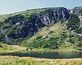
Maly Staw
(Small Pond)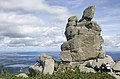
Słonecznik
(Midday Stone)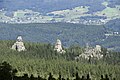
Pielgrzymy
(three stones)
Luční bouda
(meadow cottage)
Valley of the Bílé Labe
(Weißwassertal)


