
Mały Staw
|
Mały Staw Small pond |
||
|---|---|---|

|
||
|
The cirques of the small and large ponds on a topographic map |
||
| Geographical location | western Sudetes | |
| Tributaries | Łomnica | |
| Drain | Łomnica → Bober | |
| Location close to the shore |
Karpacz , Špindlerův Mlýn |
|
| Data | ||
| Coordinates | 50 ° 44'55 " N , 15 ° 42'3" E | |
|
||
| Altitude above sea level | 1183 m npm | |
| surface | 2.8 ha | |
| length | 258 m | |
| width | 182 m | |
| scope | 756 m | |
| Maximum depth | 7.3 m | |

The Mały Staw ( Small Pond ) is the smaller of two cirque lakes on the Polish side of the Smogornia ( Mittagsberg , Czech. Stříbrný hřbet ). With an area of 2.83 hectares and a depth of 7.3 meters, it is the second largest lake of glacial origin in the Giant Mountains .
location
The lake is located on the eastern slope of Mittagsberg at an altitude of 1183 m , about 1 km southeast of Wielki Staw (Big Pond) and its glacier basin. Both lakes are located near the Czech-Polish border, approx. 6 km northeast of Spindleruv Mlyn (Czech: Špindlerův Mlýn ) and 6 km west-southwest of Karpacz (Krummhübel).
Emergence
In addition to the karen of the Śnieżne Kotły (snow pits) on the High Wheel , the glacier basins on the Big and Small Pond are the most pronounced cirques that occur on the Polish side of the Giant Mountains. The basin-shaped valleys on the eastern slopes of Mittagsberg, the steep slopes of which rise over 200 meters on Mały Staw and belong to the Smogornia avalanche path, were created by the activity of Ice Age glaciers, which left deep hollows at the valley floors, in which the water then turns into mountain lakes collected. The valley-side end of the cirque is formed on Mały Staw by a rocky cirque swell and a 60-meter-high terminal moraine .
Water balance
The main tributary of the lake is the Łomnica ( Great Lomnica ), whose headwaters lie on the plateau with the Polish name Równia pod Śnieżką ( Koppenplan ) below the Schneekoppe . The Łomnica flows through the lake and also forms its drain. From here the mountain stream falls over a length of only 4.2 km as the crow flies to the Lomnitztalsperre over 500 meters into the valley. In winter and more than half of the year, the lake is covered in ice. The water is clean, clear and, as is typical for alpine mountain lakes, poor in nutrients. The water temperature does not exceed a maximum of 14 ° C even in the warmer months.
Flora, fauna and nature conservation
The Mały Staw is located in the protection zone II of the Polish national park Karkonoski Park Narodowy (KPN). The edges of the lake are determined by subalpine vegetation such as Lapland willow , dwarf birch and mountain pine . The water provides a habitat for rare species, some of which are glacial relics such as Isoetes lacustris and Seemäuschen ( Otomesostoma auditivum ), one to the order of seriata belonging Strudelwurmart . The mountain newt and brown trout as well as a melanistic form of the common toad also live here .
tourism
The lake can be reached via the path of Polish-Czech friendship (Kammweg). Another hiking trail leads towards Równia pod Śnieżką. On the north bank, about 20 meters above the Mały Staw on a lateral moraine , there is the Schronisko Samotnia ( Small Pond House ) . The first written mention of a building on the Kleiner Teich goes back to 1670; today one of the oldest youth hostels in Poland stands here.
Image gallery

Maly Staw
view from the southeast
View of the glacier basin
In the background the Schneekoppe
Schronisko Samotnia
on the left the Strzecha Akademicka refuge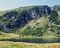
Craggy rock faces on Mały Staw


Web links
- Underwater expedition on Maly Staw and Wielki Staw I (Czech)
- Underwater expedition on Maly Staw and Wielki Staw II (Czech)
Individual evidence
- ^ Raj A., 2008: Karkonoski Park Narodowy. Agencja Fotograficzno-Wydawnica Mazury na zlecenie KPN, ISBN 83-86565-32-2
- ↑ Rapala R., 2008: Zwierzęta w Parku Karkonoskim Narodowym. Karkonoski Park Narodowy, Jelenia Góra.