
Luční hora
| Luční hora
Łączna Góra
Hochwiesenberg |
||
|---|---|---|
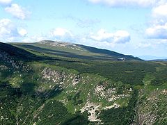
 Brunnberg and Hochwiesenberg from Schneekoppe in April |
||
| height | 1555 m nm | |
| location | Czech Republic | |
| Mountains | Giant Mountains | |
| Coordinates | 50 ° 43 ′ 40 " N , 15 ° 40 ′ 58" E | |
|
||
| rock | Mica schist , quartzite | |

The Luční hora (German: Hochwiesenberg , Polish: Łączna Góra ) is the second highest mountain in the Giant Mountains after the Schneekoppe .
location
The mountain is located in the Czech part of the mountain range and forms a double peak with the 1500 m east hilltop of the Studniční hora (German: Brunnberg ). Valley locations are 5 km southeast of Pec pod Sněžkou (German: Petzer ) and about 5.5 km to the west of Špindlerův Mlýn (German: Spindleruv Mlyn ) to whose municipality the summit belongs.
The highest point is found in a flat, relatively extensive area created by leveling , which is bordered on the north, south-west and south-east by steep avalanche slopes . In the other directions mountain ridges go down to the neighboring peaks. The most important of these is the eastern “Inner Ridge” of the Giant Mountains, which is formed to the west by the elongated ridge of the goat's back (Czech: Kozí hřbety ). In the east it is connected to the Brunnberg via a saddle . From there the ridge continues to the Koppenplan (Polish: Równia pod Śnieżką ) below the Schneekoppe.
Another ridge branches off to the south, branching off at the Plattenberg (Czech: Zadní Planina ) into the Wachur ridge and the Fuchsberg ridge . Thus, the Hochwiesenberg is the most important starting point for the Krkonošské rozsochy , the so-called southern branch ridges of the Giant Mountains.
Nearby peaks
| Kozí hřbety | Smogornia | White meadow |
| Stoh |
.svg)
|
Studniční hora |
| Zadní Planina | Liščí hora | Lesní hora |
geology
The mountain is made up of layers of mica schist arranged in heaps, which are criss-crossed by quartzite veins. The structure of the subsurface in the ridge region was created by processes of cryoturbation . In the Czech Republic it is a unique example of the occurrence of unsorted frost pattern soil .
Hydrology
The area is characterized by cryoplanar terraces , rocky seas and rock heaps , which has a not insignificant effect on the water balance because the water runs off quickly and is hardly stored. Together with the Brunnberg, the Hochwiesenberg forms one of the most important source areas of the Giant Mountains. The Modrý potok (German: Rauschenbach ) rises on the south-eastern slope and, reinforced by numerous smaller streams, flows into the Modrý důl (German: Blaugrund ) of the Úpa (German: Aupa ). On the southwest side, below the saddle of the Plattenberg, there are the sources of Svatopetrský potok (German: groundwater ), which still absorbs the water of the Lovčí potok (German: Jägerbach ) coming from the western slope and many nameless rivulets before it enters the Elbe in Spindleruv Mlyn flows out. The entire northern area drains into the Bílé Labe (German: white water ). This largest tributary and most important source stream of the Elbe flows in the Weißwassergrund ( Důl Bílého Labe ), which belongs to the legendary area of the Siebengrund (Czech: Sedmidolí ). All named waters belong to the Elbe - North Sea river system .
history
The Schlesierweg, an old trade route leading past the summit, led from Vrchlabí (German: Hohenelbe ) to the salt deposits in the Bohemian Basin with the Silesian towns of Krummhübel (Polish: Karpacz ), Hirschberg (Polish: Jelenia Góra ) and Schmiedeberg (Polish: Kowary ) association. The path contributed significantly to the settlement of the Giant Mountains and where the path on the northern slope on the White Meadow (Czech: Bílá louka , Polish: Biała Łąka ) passes the source area of the Weißwasser, the Wiesenbaude (Czech: Luční bouda ) was the first mountain hut in the Giant Mountains.
As part of the work for the border fortification system of the Czechoslovak Wall , several bunkers were built on the mountain slopes. A goods cableway was operated from Petzer between 1937 and 1938 to transport the necessary building materials. At an altitude of 1527 m, the highest fortification in the Czech Republic still bears witness to these war preparations.
Tourism and nature protection
The mountain is located in Zone I of the Krkonošský národní park (KRNAP) National Park , so strict nature protection regulations apply. Leaving the paths and thus access to the summit is prohibited. But there are differently marked hiking routes on which the mountain top can be circled.
▬ - With a red milestone : the old Buchar path runs (Czech Stara cesta Bucharova of Spindleruv Mlyn Coming). First it goes over the highest peak of the Ziegenrück and the lookout point "Krakonoš" (1422 m), then past the Rennerbrunnen at the former Rennerbaude and finally on the west and northwest slopes of the mountain to the Wiesenbaude.
▬ - Signed in yellow, also coming from Spindleruv Mlyn, the Dřevařská cesta (translated: Holzweg , German: Schneeschubweg ) leads to the Weißwasserbaude (Czech: Bouda u Bílého Labe ) in the Weißwassertal .
▬ - Follow a green sign from Petzer to the crossroads at Chata Výrovka , a mountain hut that used to be called Tannenbaude or Geiergucke. Here you can turn right and on the red signposted path you first reach a chapel, which has been established as a memorial for the victims of the mountains (Czech: Pamatnik obetem hor , 1509 m) since 1957 , before continuing in the direction of Wiesenbaude. If you take the path straight ahead, you can hike through the Dlouhý důl (German: Langer Grund ) and come down to Svaty Petr , a district of Spindleruv Mlyn.
Pictures from the area

The summit in August 2015

Stream on the White Meadow
Luční hora and Luční bouda from Sněžka

The memorial
to the victims of the mountains 1)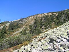
Sea of rocks and typical vegetation on the goat back


1) Another memorial for the victims of the mountains is located in Melzergrund on the eastern slope of the Kleine Koppe in Poland.
literature
- Julius Büdel: Ice Age and recent weathering and erosion in the formerly not icy part of Central Europe . Perthes, 1937, p. 71 .
- Bernhard Pollmann: Giant Mountains . Bergverlag Rother, 2015, ISBN 978-3-7633-4222-8 , p. 65 ( google.de ).
Web links
- Ascent to Luční hora (Czech)
- Luční hora - info, photos (Czech)
Individual evidence
- ↑ Peter Göbel, Investigations on Gotezierrassen in the West Harz , page 1 ( Memento from March 20, 2017 in the Internet Archive ) (PDF, 10 MB)
- ↑ Silesian Society for Geography: Publications, Volumes 17-18 . Breslau 1933, p. 16 .
- ↑ Hikes on the Giant Mountains Ridge