
Studniční hora
| Studniční hora
Brunnberg
|
||
|---|---|---|
 View of the snowy north slope |
||
| height | 1554 m nm | |
| location | Královéhradecký kraj , Czech Republic | |
| Mountains | Giant Mountains | |
| Coordinates | 50 ° 43 '38 " N , 15 ° 42' 22" E | |
|
||
| rock | Mica schist , porphyry granite | |

The Studniční hora (German: Brunnberg ) is located in the Czech part of the Giant Mountains and is the third highest mountain in the mountains after the Schneekoppe and the Hochwiesenberg (Czech: Luční hora ). The mountain forms a double peak with the 1555 meter high Hochwiesenberg to the west.
location
The valley locations are Špindlerův Mlýn (German: Spindleruv Mlyn ), about 7 km to the west, and Pec pod Sněžkou (German: Petzer ), just under 4 km to the south-east . From the Schneekoppe, the Hochwiesenberg, 1.7 km behind the summit, could almost be overlooked. Both differ only one meter in height, but the smaller Brunnberg is the much more striking appearance.
Its eastern slopes, in particular the walls of the glacial cirques Large and Small Brunnberg pit (Czech: Velká a Malá Studniční jáma ) in the southeast and the Upa pit limit in the Northeast along with the opposite slopes of the Snow Mountain and the marked section of the valley of Aupakante (Czech: Úpská hrana ) on the Koppenplan (Polish: Równia pod Śnieżką ) in the northeast the Riesengrund (Czech: Obří důl ). This valley of glacial origin is one of the most famous motifs in the mountains.
The avalanche slope in the south is best known for a snow field called the “Map of the Republic”. In winter, a thick blanket of snow accumulates here, which remains until the beginning of the warm season. Its shape is reminiscent of the representation of the country on a map. The north slope, which is also highly prone to avalanches, lies below the saddle that connects to the Hochwiesenberg in the west.
Nearby peaks
| White meadow | Koppenplan | Schneekoppe |
| Hochwiesenberg |
.svg)
|
|
| Zadní Planina | Lesní hora | Růžová hora |
Names
Like many place names in the region, the Czech name “Studniční hora” is a translation of the original German name. After the Second World War and the expulsion of the Germans , the old names were systematically replaced by Czech expressions, which was probably mainly for reasons of identity . The "Brunnberg" was renamed relatively late in 1952. Before that, the mountain was also called "Steinboden", for which there is also an equivalent in Czech with "Kamenitá pláň" . The independent name “Brandkoppe” existed for its summit.
Hydrology
On the south side of the saddle below the Blaugrund pass (Czech: Modré sedlo , 1497 m) the Modrý potok (German: Rauschenbach ), which is broadened by countless smaller waterways, rises in the Modrý důl (German: Blaugrund ) from the wildly romantic mountain river Aupa (Czech : Úpa ) flows in.
The northwest slope is drained into the Bílé Labe (German: white water ), which rises below the northern slope. This largest tributary and most important source brook of the Elbe flows in the Weißwassergrund ( Důl Bílého Labe ), which is part of the mythical Siebengrund (Czech: Sedmidolí ).
On the north side, the outflow of rain helps to keep the Aupa peat bog between Koppenplan and Weißer Wiese (Czech: Bílá louka , Polish: Biała Łąka ) moist. The water feeds the springs of the Aupa, which, however, takes the route to the south and rushes over the already mentioned Aupakante and the upper Aupafall (Czech: Horní Úpský vodopád ) into the Aupa pit (Czech: Úpská jáma ) and finally rushes with the Elbe flows into the North Sea .
Only a few meters away, literally on the other side, lies the headwaters of the Great Lomnica (Polish: Łomnica ). The stream flows through the mountain lake Mały Staw (German: Small pond ). On the way into the valley, the mountain stream overcomes a length of only 4.9 km as the crow flies over 700 meters in altitude and swells into one of the most rapid and dangerous rivers in the Giant Mountains. Therefore it is dammed for flood protection in the Lomnitztalsperre . After about 15 more kilometers it flows into the Bober and is therefore part of the Oder - North Sea river system .
The area around the Brunnberg and Hochwiesenberg, which is exceptionally rich in water, is therefore one of the most important source areas of the Giant Mountains.
Flora and fauna

Remnants of alpine pastures and mountain meadows have been preserved on the slopes and the round summit crest; only the eastern slope is overgrown with mountain pines . The glacier basins in the east are home to places that are known as “zahrádka” ( little gardens ) thanks to their unique botanical diversity .
The “Devil's Garden” (Czech: Čertova zahrádka ) in the Kleiner Brunnberggrube, for example, is the only place in the Giant Mountains where spring pasque flower ( Pulsatilla vernalis ) and Alpine sweet clover ( Hedysarum hedysaroides ) grow. In addition, other rare flowering plants thrive here, such as the Turk's Union ( Lilium martagon ), the large-flowered foxglove ( Digitalis grandiflora ) or the curly furry fern ( Cryptogramma crispa ), which is highly endangered here .
The “Rübezahls Gärtchen” (Krakonošova zahrádka) in the Aupa pit is of similar importance. The insects, spiders and snails that live here are the food source for many species of birds, such as B. Mountain and meadow pipit (Anthus spinoletta or pratensis) or the alpine brownelle .
Tourism and nature protection
The mountain is located in the area of the National Park Krkonošský národní park (KRNAP). Particularly strict nature conservation regulations apply in Zone I and the paths must not be left.
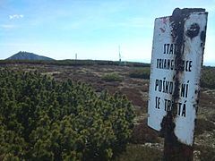
So direct access is blocked and the summit can only be circumnavigated. To do this, the crossing at Chata Výrovka must first be reached. The hut , which used to be called "Tannenbaude", is still known today as the "Geiergucke" because the customs officers ambushed the smugglers here . There are two hiking routes, apart from the K1A Žacléř - Harrachov cycle route .
▬ - From Petzer,followinga green sign , over the Richterbauden ( Rychtářova Bouda ) or, also marked in green, from Svaty Petr , a district of Spindleruv Mlyn, the course of the Svatopetrský potok (German: groundwater ) accompanying through the Langen Grund (Czech : Dlouhy důl ).
▬ - On a red signposted path in the direction of the main ridge you first reach a chapel on the Blaugrundpass, which was set up in 1957 as a memorial for the victims of the mountains (Czech: Pamatnik obetem hor , 1509 m), before it now goes slightly downhill towards Wiesenbaude.
▬ - The blue waymark leads you from the oldest mine in the Giant Mountains, along the Czech-Polish border and the Aupakante, to the giant saddle (1395 m, Czech: Obří sedlo , Polish: Przełęcz pod Śnieżką ). Here is the Schlesierhaus (Polish: Slaski dom ), where a tourist border crossing was set upbefore thetwo countries joined the EU .
The path with the blue waymark forks here. At the same height it continues on the path of Polish-Czech friendship . Down the valley on the so-called Šourek path, close to the western slope of the Schneekoppe, it goes steeply down into the Riesengrund. For the soft knees that one can have on the irregular steps when descending, there is a rich compensation with the unique view of the Brunnberg, the valley formed by the Aupa glacier and the upper Aupafall.
Shortly before reaching the alpine tree line , the path becomes less steep. There are more interesting sights nearby. "Rübezahls Gärtchen", the lower Aupafall or the old waterworks, with which the water was pumped to the Schneekoppe. On the way down to Petzer, you will also pass many disused ore mines, of which the “Kovárna” tunnel can even be visited.
Pictures from the area
Measurement point
at the summit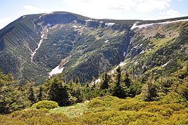
View of Riesengrund, Aupakante and ... 1)
... also from the west 2)

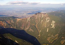
Distant view of Brunnberg
and Schneekoppe ... 3)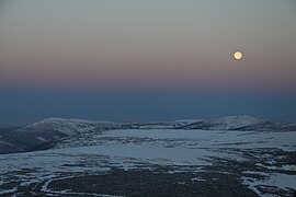
View from the Schneekoppe at night 4)


.JPG)
1) The young Aupa falls over the edge of the Aupa (right part of the picture) at a height of 1,363 meters into the Aupa pit , which forms the end of the giant ground on the mountain side.
2) This picture was taken approximately from the direction of the Fuchsberg ( Liščí hora )
3)… seen from Petzer, below the Schwarzenberg (Czech: Černá hora ).
4) Panorama to the west: Brunnberg to the left, behind it, slightly to the center of the picture, the Hochwiesenberg. On the far right you can see the building of the former snow pit hut (Polish: Schronisko nad Śnieżnymi Kotłami ) above the snow pits (Polish: Śnieżne Kotły ) on the high wheel .
literature
- Frank Schüttig: “Riesengebirge. With hiking tips, winter sports guides and trips to the Jizera Mountains ” . Trescher, 2016, ISBN 978-3-89794-361-2 ( google.de ).
Web links
Individual evidence
- ↑ a b information page from Hory-Krkonose.cz (Czech)
- ↑ Data from a very detailed map on mapy.cz (Czech)