
Svatopetrský potok
|
Svatopetrský potok groundwater |
||
 Adolph Rehnert - Parthie in Alt St. Peter am Klausenwasser 1892 |
||
| Data | ||
| location | Czech Republic | |
| River system | Elbe | |
| Drain over | Elbe → North Sea | |
| source | at Chata Výrovka 50 ° 43 ′ 7 ″ N , 15 ° 40 ′ 59 ″ E |
|
| muzzle |
Elbe in Spindleruv Mlyn Coordinates: 50 ° 43 '26 " N , 15 ° 36' 19" E 50 ° 43 '26 " N , 15 ° 36' 19" E
|
|
| Left tributaries | Hluboká struha, Černá struha | |
| Right tributaries | Lovčí potok | |
.svg) Elevation profile: ➀ = source, ➁ = mouth, |
||
The Svatopetrský potok (German: groundwater ) is a left tributary of the Elbe (Czech: Labe ) in the Czech part of the Giant Mountains .
Location and course
The Svatopetrský potok rises on the southern slope of the Hochwiesenberg (Czech: Luční hora ), which together with the northern slope of the Plattenberg (Czech: Zadní Planina ) forms the end of the trough valley , which is shaped by the bed of the small river.
After a gradient of more than 300 meters for a little more than the first kilometer, the stream winds clockwise around the southwest slope of the Eisenkoppe (Czech: Železná hora ), a pre-peak of the Hochwiesenberg that does not end with the Eisenberg (Czech: Železný vrch ) the goat's back (Czech: Kozí hřbety ) should be confused. Then he changes the direction of rotation and creates an S-shaped river loop by flowing around the north slope of the haystack. Before it flows into the Elbe and describes a second S, it changes direction again at the 876 meter high Kohlbusch (Czech: Kohlova houština ), a hill that is popular for tobogganing .
The entire valley is repeatedly threatened by the forces of nature. Disastrous floods often occur when the stream cannot absorb the influx from the surrounding mountains. During the cold season there is also the risk of avalanches . Their paths are carefully observed in winter and spring in order to prevent major damage with the help of targeted blasting if necessary. Like the water, they take the same route over the numerous ditches and side valleys .
The most important ones are in the direction of flow, coming from the right: Pramenný důl (German: Winkelschober ) with the Pramenný potok brook , Lovecký důl with the Lovčí potok brook (translated: Jägerbach , German: Hohle Grundwaser ) and Hrazený důl with the Hrazený potok brook , its Valley "Grüner Grund", or at times like the main valley, "Klausengrund" was called.
From the left the trenches Vojenský žlab and Příkrý žlab flow into the northern slope of the Plattenberg. The following smaller trenches all drain the northern slopes of the haystack. These are Borůvková strouha (German: Beerhübelgraben ), Hluboký strouha (German: Tiefer Graben ), Krátký strouha (German: Kleiner Graben ), Černý strouha (German: Schwarzer Graben ) and Vysoký strouha (German: Hoher Graben ). Finally, there is Mumlavý strouha (German: Murmelgraben ) on the northeast slope of the Hromovka Mountain (German: Tannenstein , 1031 m).
Unfortunately, in the course of the forced renaming of many originally German place names after 1945 , numerous inconsistencies, mix-ups and the complete elimination of names. The adjacent height profile can also be created with German names on Commons .
Hydrology
Gewässerkundlich strictly speaking, is the mountain actually the first left tributary of the Elbe, because the Bílé Labe (German: white water ) springs not only higher, but is also longer than the right coming eponymous Elbbach. Unlike these two source rivers of the Elbe, the Svatopetrský potok is not one of the seven or eleven wells of the Elbe .
As already mentioned, the source is located south of the Hochwiesenberg. Specifically about 200 m north of the mountain cottage Chata Výrovka at an altitude of about 1,390 meters. It draws a large part of its water from here and the neighboring Plattenberg. Like the white water flowing in parallel, it is also the precipitation, which the subsoil on the elongated goat's back is hardly able to store, which allows it to grow further. In addition, there is rain and meltwater, which is contained in rather smaller streams and runs down the northern slopes of the Haystack (Czech: Stoh ).
Names
Over the course of time, the brook has had various names that are often associated with its use. The German language was particularly influential. The valley itself is called "Dlouhý důl" in Czech, "Peters long reason" in German, "Langer Grund" for short and in earlier times occasionally also Klausengrund or Klausengraben.
When copper and silver ores were mined for the first time in the 16th century, soap as a term for a deposit became a common part of the name, e.g. B. Elbseifen for the Elbbach or here in the name "Peterseifen".
After mining came to a temporary standstill and forestry gained greater importance, it was given the name "Klausenwasser". This was in connection with a so-called hermitage , a weir that had been built to dammed the water on the upper reaches and used to drift the logs .
Later a new name came into fashion. Until the confluence of today's “Pramenný potok”, which at that time was called “Small Groundwater” to distinguish it, the source stream was called “Large Groundwater”. After the confluence, only “groundwater” was spoken of. The "brook of St. Peter", as the literal translation, is also often referred to as "Dolský potok" in Spindleruv Mlyn, which in comparison with similar place names means "Grundbach"; So, as with many names in the region, is very close to the German term.
Tourism and nature protection
The lower part of the stream is no longer part of the Krkonošský národní park (KRNAP) national park , but the administration has added it to the list of breeding streams. In principle it is not allowed to fish in these waters, because they serve to reproduce various endangered fish species. In the upper part, you have to pay attention to the strict nature protection regulations, which, among other things, make leaving the path a criminal offense.
▬ - A green marked hiking trail leads close to the stream. Its flat section in the area of “Skiareál Sv. Petr ”is used as a cross-country ski run in winter, the higher areas are then often closed due to the danger of avalanches. In summer it is possibleto hiketo Chata Výrovka . The hut , which used to be called "Tannenbaude", is still known today as "Geiergucke" because the customs officers , literally called "vultures" in the vernacular, ambushed the smugglers .
Surroundings
In the upper part of the valley, at the end of the so-called “Červenka Mulde”, a symbolic burial mound made of stones is clearly visible (1080 m). It is the memorial to the Czechoslovak slalom skier Oldřich Červenka, who died here on March 2, 1951 during a training run in an avalanche. At the time of the accident, the ditch, which sloped steeply into the Langen Grund, did not yet have a Czech name and only a few people knew the German place name "Winkelschober". Therefore, the term “Červinkově muldě” quickly caught on. Nobody actually uses the official name “Pramenný důl” (translated: source reason ), which was invented later .
photos

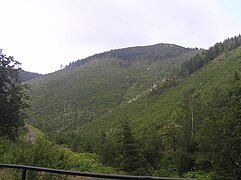
View
of the Svatý Petr valley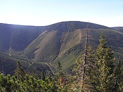
Stoh mountain above the Svatý Petr valley
Dlouhý důl with the Stoh in the background

The back of the goat
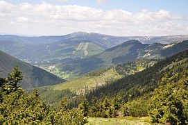
View from Chata Výrovka to Spindleruv Mlyn

Estuary into the Elbe
(in the background)
.jpg)


2009.jpg)

Web links
The Elbe in the Giant Mountains , page 16, timber rafting from the Giant Mountains to Vrchlabí (Hohenelbe)
Individual evidence
- ↑ Comparative analysis of the avalanche situation in the Czech part of the Giant Mountains (PDF, Czech, 2.53 MB)
- ↑ Johann Gottfried Sommer, The Kingdom of Böhmen: statistically-topographically represented , Volume 1, page 186
- ↑ Barbora Chytilová, HISTORICKÉ TOPOGRAFICKÉ DATABÁZE OKOLÍ LUČNÍ BOUDY (PDF, Czech, 5.71 MB)
- ↑ A night of horror in Sankt Peter
- ↑ a b Fishing in the Giant Mountains
- ↑ Avalanche victims in the "Červenka Mulde"
- ↑ The impatient Olík Červenka (PDF, 3.93 MB)