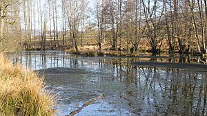
Sahlensee
| Sahlensee | ||
|---|---|---|

|
||
| Sahlensee near Mernes | ||
| Geographical location | Main-Kinzig district (Hesse) | |
| Data | ||
| Coordinates | 50 ° 13 '1.8 " N , 9 ° 29' 19.8" E | |
|
|
||
| Altitude above sea level | 195 m above sea level NHN | |
| surface | 0.7 ha | |
| length | 160 m | |
| width | 30 m | |
The Sahlensee is a small lake near Bad Soden-Salmünster in the Main-Kinzig district in the Hessian Spessart .
description
The Sahlensee is located in the Jossatal , south of the Mernes district , near the boundary with the Jossgrund district of Burgjoss , at around 195 m above sea level. NHN . Its water surface is about 0.7 hectares . It lies between the state road 3197 and the Jossa, in the "Sahlensee bei Mernes" nature reserve named after it . The 14.22 hectare nature reserve was designated in 1979. The Mohrenbach runs north of the Sahlensee and about a kilometer east of the state border with Bavaria .
See also
- List of lakes in the Spessart
- List of lakes in Hessen
- List of nature reserves in the Main-Kinzig district
Web links
Commons : Sahlensee - Collection of images, videos and audio files
