
Saint John (Jersey)
| Saint John | |||
|---|---|---|---|
|
|||
| Coordinates | 49 ° 14 ′ 42 " N , 2 ° 8 ′ 9" W | ||

|
|||
| Symbols | |||
|
|||
| Basic data | |||
| Country | jersey | ||
| ISO 3166-2 | JE | ||
| surface | 8.7 km² | ||
| Residents | 2911 (2011) | ||
| density | 334.6 Ew. / km² | ||
| Website | www.parish.gov.je/stjohn/ (English) | ||
 The meeting house of Saint John
|
|||

.svg)
Saint John ( Jèrriais : St Jean ) is one of the twelve parishes of Jersey . The municipality is located in the north of the island. It covers 5116 vergées (9 km², 8% of the land area of Jersey) and is largely rural, except for the small community center. Neighboring parishes are Saint Mary in the west, Trinity in the east, and Saint Lawrence and Saint Helier in the south.
In the far north, at Ronez Point , is one of the last places where the typical Jersey granite is still mined.
Attractions

The Center Stone is traditionally considered to be the center of the island, although far removed from the actual geographic center. It can be found in Sion (Vingtaine de Hérupe): the stone itself is of prehistoric origin and could have come from a nearby dolmen, which no longer exists.
The megalithic complex of La Hougue Boëte is located in the municipality .
The cliffs of the north coast offer tourists breathtaking views. Interesting tourist destinations also include Mourier Bay and Bonne Nuit Bay . Nearby is also the second highest mountain on the island: Mont Mado (437 ft , 133 meters).
La Route du Nord
The street La Route du Nord was planned and built during the German occupation of Jersey 1940-1945. Today it is dedicated to the victims of the Second World War .
Population development
Historical populations:
- 1991: 2440
- 1996: 2520
- 2001: 2618
- 2011: 2911
In terms of population, St. John is penultimate in Jersey.
politics
The municipality is divided into three parts ( vingtaines ):
St. John forms an electoral district and elects an MP.
All parishes in Jersey, including Saint John, have an honorary police force made up of volunteer members who have certain rights organized in a police-like manner.
education
Saint John has with the St. John's School a primary school, a crèche (nursery) is connected.
Partner municipality
The only partner church is currently (2017):
![]() Le Teilleul ( Manche department ), France
Le Teilleul ( Manche department ), France
Photo gallery

Parochial Church of St. John

War memorial
1914–1918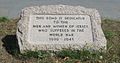
Dedication stone for the La Route du Nord


Individual evidence
- ↑ Size and land cover of Jersey , Area of Jersey by Parish (2017), on gov.je . Retrieved September 9, 2017.
- ^ Census 2011 , accessed August 25, 2017.
- ^ List of Elementary Schools in Jersey , accessed August 25, 2017.