Salacgrīva
| Salacgrīva ( German : Salismünde) | ||
|---|---|---|
 |
|
|
| Basic data | ||
| State : |
|
|
| Landscape: | Livonia ( Latvian : Vidzeme ) | |
| Administrative district : | Salacgrīvas novads | |
| Coordinates : | 57 ° 45 ' N , 24 ° 21' E | |
| Residents : | 3,010 (Jan 1, 2016) | |
| Area : | 12.57 km² | |
| Population density : | 239 inhabitants per km² | |
| Height : | 4 m | |
| City law: | since 1928 | |
| Website: | www.salacgriva.lv | |
| Post Code: | LV-4033 | |
| ISO code: | ||
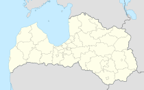
Salacgrīva (German: Salismünde , Estonian: Salatsi ) is a port city with about 3000 inhabitants on the Riga Bay in northern Latvia and the center of the administrative district of the same name. In 2016 it had 3,010 inhabitants.
history
The area was inhabited by the Livs . From 1207 there was a trading post of the Archbishop of Riga at the mouth of the Salaca , which was secured with a castle from 1226. After 1561 the area belonged to Poland-Lithuania. The castle was destroyed in the wars with Sweden. After the place became part of the Russian Empire in 1721 , the Livonian language slowly died out here. In 1870 the river bed was deepened and a port was opened. This led to the settlement of industrial and craft businesses. However, the importance of Salacgrīva declined when a port was also opened in neighboring Ainaži in 1903 , which in 1912 received a railway connection (narrow gauge).
Only after the Second World War did the population rise again after a large fish processing factory was built.
In 2009, the city of Salacgrīva merged with the city of Ainaži and the three rural communities (pagasts) Ainaži, Liepupe and Salacgrīva to form the administrative community Salacgrīvas novads .
people
- Indulis Emsis (* 1952), biologist and politician
literature
- Hans Feldmann , Heinz von zur Mühlen (Hrsg.): Baltic historical local dictionary, part 2: Latvia (southern Livland and Courland). Böhlau, Cologne 1990, ISBN 3-412-06889-6 , p. 541.
- Astrīda Iltnere (ed.): Latvijas Pagasti, Enciklopēdija. Preses Nams, Riga 2002, ISBN 9984-00-436-8 .

