San Pedro y San Pablo Teposcolula
| San Pedro y San Pablo Teposcolula | ||
|---|---|---|
|
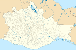
Coordinates: 17 ° 31 ′ N , 97 ° 29 ′ W San Pedro y San Pablo Teposcolula on the map of Oaxaca
|
||
| Basic data | ||
| Country | Mexico | |
| State | Oaxaca | |
| Municipio | San Pedro y San Pablo Teposcolula | |
| Residents | 1737 (2010) | |
| Detailed data | ||
| surface | 2.32 km 2 | |
| Population density | 749 inhabitants / km 2 | |
| height | 2180 m | |
| San Pedro y San Pablo Teposcolula - Dominican Convent | ||
| Capilla abierta and church facade | ||
San Pedro y San Pablo Teposcolula is a place with almost 1,800 inhabitants and the administrative seat of the municipality of the same name ( municipio ) with a total of around 4,200 inhabitants in the northwest of the state of Oaxaca in southern Mexico . The place has been classified as Pueblo Mágico since 2015 .
Location and climate
The place San Pedro y San Pablo Teposcolula is located in the Mixteca Alta about 385 km (driving distance) southeast of Mexico City near the main road to Oaxaca de Juarez at an altitude of about 2180 m ; to Oaxaca it is another 120 km in a southeast direction. The neighboring town of San Juan Teposcolula is only 10 km away. The climate is dry and warm; the abundant rain for the region (approx. 730 mm / year) falls mainly during the summer half-year.
Population development
| year | 2000 | 2005 | 2010 |
| Residents | 1,318 | 1,411 | 1,737 |
Already in pre-Hispanic times, the area was of Mixtecs settled -Indianern; in the 15th century, Nahuatl- speaking groups from the north also joined. The residents of the place usually speak Mixtec or Nahuatl dialects among themselves .
economy
In pre-Hispanic times, the place was also a supraregional important market and trade center. Today the people of the region live largely self-sufficient from the yields of their fields (corn, wheat) and gardens (potatoes, beans, tomatoes, chilli, etc.). Cattle breeding is only practiced to a limited extent (chickens, turkeys). There are small traders and craftsmen in the village itself; Hats , bags, etc. are made from wild, small Jipijapa palms .
history
The Indians living here resisted both the Aztec and the Spanish occupation, but a few years after the Spanish conquest of the Aztec Empire (1519–1521), monks of the Dominican Order came and founded one of the largest mission stations in southern Mexico. Presumably the imposing courtyard facade of the complex was redesigned in the 17th century and the older "open chapel" was replaced by a new and more beautiful one.
Attractions
- The construction of the monastery and the church of San Pedro y San Pablo , consecrated to the apostles Peter and Paul , began around 1650. The facade of the building complex, oriented towards a walled atrium , is divided into three parts: on the right the unadorned facade of the monastery, in the middle the facade of the monastery church designed in the Renaissance style and on the left the polygonally broken capilla abierta . On the side walls of the simply vaulted nave there are less significant altars from the 18th and 19th centuries; the main altar, however, is designed in the late Baroque style of Churriguerism . A figure of Christ with open leg wounds (Señor de las Vidrieras) is particularly venerated.
- The yoke inside the Capilla abierta is covered by an elaborately designed star vault.
- The restored and almost modern-looking “village chief's house” (casa de la cacica) is located within the remains of an older wall not far from the church .
- The town hall (Palacio Municipal) is a pretty neo-baroque building with arcades (portales) and an attached clock gable in the middle.
See also
Web links
- San Pedro y San Pablo Teposcolula - Information (INAFED, Spanish)
- San Pedro y San Pablo Teposcolula - sights etc. (Spanish)


