
San Vicente de la Barquera
| San Vicente de la Barquera municipality | |||
|---|---|---|---|
| coat of arms | Map of Spain | ||

|
|
||
| Basic data | |||
| Autonomous Community : |
|
||
| Comarca : | Costa occidental | ||
| Coordinates | 43 ° 23 ′ N , 4 ° 24 ′ W | ||
| Height : | 15 msnm | ||
| Area : | 41.5 km² | ||
| Residents : | 4,124 (Jan 1, 2019) | ||
| Population density : | 99.37 inhabitants / km² | ||
| Municipality number ( INE ): | 39080 | ||
| administration | |||
| Mayor : | Julián Vélez González | ||
| Website : | www.sanvicentedelabarquera.org | ||

San Vicente de la Barquera is a municipality in the autonomous community of Cantabria in northern Spain , around 40 km west of Santander . The main town also includes the villages: Abaño, La Acebosa, El Barcenal, Gandarilla, Hortigal, Los Llaos and La Revilla.

San Vicente de la Barquera at sunrise, in the background the Picos de Europa
|


history
There are finds from the Bronze Age and in El Barcenal from the megalithic . Furthermore, the Roman port Portus Vereasueca was identified with San Vicente de la Barquera.
In the middle of the 8th century the city was conquered by the Muslims during the Rekonquista by King Alfonso I. He built a castle that can be seen as the nucleus of today's city. After a period of economic growth, the city became legally independent under King Alfonso VII in 1210. The first set of rules for the fishing guild dates from 1330. In the 15th century the city was ravaged by fires and plague epidemics.
| year | 1900 | 1950 | 1970 | 1990 | 2005 |
|---|---|---|---|---|---|
| Residents | 1,769 | 3,313 | 4.016 | 4,521 | 4,461 |
Attractions
San Vicente de la Barquera has an interesting ensemble of old houses. The center of San Vicente was declared a cultural asset of Cantabria in 1987. Particularly noteworthy are the church of Santa María de los Ángeles , built between the 13th and 16th centuries , the castle and the remains of the city wall. The 600 meter long Maza Bridge with its 28 arches dates from the 16th century and was built on the orders of the Catholic Kings . The Parral Bridge dates from the 18th century. The sandy beaches of Fuentes, Primera de San Vicente, El Rosal, El Tostadero, Merón and Gerra are noteworthy.
San Vicente de la Barquera is part of the Camino de la Costa Way of St. James .

The Maza Bridge from San Vicente

Church of San Vicente de la Barquera

Castle and Church of San Vicente de la Barquera

Oyambre Natural Park east of San Vicente
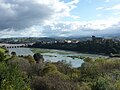
Estuary of the Río Escudo and San Vicente


Twin town
There are partnerships with Pornichet in the French Loire-Atlantique department .
Web links
- San Vicente de la Barquera (Spanish)
Individual evidence
- ↑ Cifras oficiales de población resultantes de la revisión del Padrón municipal a 1 de enero . Population statistics from the Instituto Nacional de Estadística (population update).
Alfoz de Lloredo | Ampuero | Anievas | Arenas de Iguña | Argoños | Arnuero | Arredondo | El Astillero | Bárcena de Cicero | Bárcena de Pie de Concha | Bareyo | Cabezón de la Sal | Cabezón de Liébana | Cabuérniga | Camaleño | Camargo | Campoo de Enmedio | Campoo de Yuso | Cartes | Castañeda | Castro Urdiales | Cieza | Cillorigo de Liébana | Colindres | Comillas | Los Corrales de Buelna | Corvera de Toranzo | Entrambasaguas | Escalante | Guriezo | Hazas de Cesto | Hermandad de Campoo de Suso | Herrerías | Lamasón | Laredo | Liendo | Liérganes | Limpias | Luena | Marina de Cudeyo | Mazcuerras | Medio Cudeyo | Meruelo | Miengo | Miera | Molledo | Noja | Penagos | Peñarrubia | Pesaguero | Pesquera | Piélagos | Polaciones | Polanco | Potes | Puente Viesgo | Ramales de la Victoria | Rasines | Reinosa | Reocín | Ribamontán al Mar | Ribamontán al Monte | Rionansa | Riotuerto | Las Rozas de Valdearroyo | Ruente | Ruesga | Ruiloba | San Felices de Buelna | San Miguel de Aguayo | San Pedro del Romeral | San Roque de Riomiera | San Vicente de la Barquera | Santa Cruz de Bezana | Santa María de Cayón | Santander | Santillana del Mar | Santiurde de Reinosa | Santiurde de Toranzo | Santoña | Saro | Selaya | Soba | Solórzano | Suances | Los Tojos | Torrelavega | Tresviso | Tudanca | Udías | Val de San Vicente | Valdáliga | Valdeolea | Valdeprado del Río | Valderredible | Valle de Villaverde | Vega de Liébana | Vega de Pas | Villacarriedo | Villaescusa | Villafufre | Voto