Santa Rosa (New Mexico)
| Santa Rosa | |
|---|---|
| Nickname : The City of Natural Lakes. | |
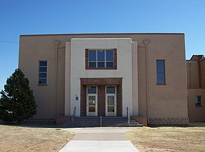
 new wing of the Guadalupe County Courthouse |
|
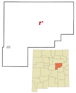
| Santa Rosa in Guadalupe County | |
| Basic data | |
| State : | United States |
| State : | New Mexico |
| County : | Guadalupe County |
| Coordinates : | 34 ° 57 ′ N , 104 ° 41 ′ W |
| Time zone : | Mountain ( UTC − 7 / −6 ) |
| Residents : | 2,744 (as of: 2000) |
| Population density : | 249.5 inhabitants per km 2 |
| Area : | 11.1 km 2 (approx. 4 mi 2 ) of which 11.0 km 2 (approx. 4 mi 2 ) are land |
| Height : | 1407 m |
| Postal code : | 88435 |
| Area code : | +1 575 |
| FIPS : | 35-70670 |
| GNIS ID : | 0918353 |
| Website : | www.srnm.org |
| Mayor : | Albert E. Campos |
Santa Rosa is a city in Guadalupe County in the US state of New Mexico in the United States with 2,744 inhabitants ( as of 2000) . Santa Rosa is the county seat of Guadalupe County. It lies between Albuquerque and Tucumcari , on the Pecos River . The city lies on the western edge of the Llano Estacado .
history
“Aqua Negra Chiquita” (little black water) was the first European settlement in the area in 1865. The name was built in 1890 in reference to a chapel built by the city's founder Don Celso Baca and named after his mother, Saint Rosa of Lima , the name of the city was changed in 1890 to "Santa Rosa" (the holy rose). The "rose" can also allude to the roses in the legend of the Lady of Guadalupe and symbolize the Catholicism of the Spanish settlers living in this area .
traffic
Interstate 40 , US Highway 54, and US Highway 84 intersect in Santa Rosa . Route 66 ran through the town between 1926 and 1937 . In the early 1900s, Santa Rosa was connected to the Chicago, Rock Island and Pacific Railroad network .
geography
Santa Rosa has many natural lakes, an anomaly in the arid desert climate. The origins of the lakes are karst funnels in limestone that fill with water. Many are connected to one another by an underground natural water tunnel system. The most famous lake is the Blaue Loch ( Blue Hole ), a 25 meter deep, 16 ° C cool water.
Demographics
After the census of 2000, there 2,744 people in 898 households and 616 families lived. The population density was 249.3 inhabitants per km ². The racial the population was composed of 57.47% White, 2.19% African American, 1.75% Native American, 0.87% Asian, 0.04% Pacific Islander, 33.13% other ethnicities and 4.56% mixed race . Hispanic or Latino of any race was 81.16% of the population.
Of the 898 households, 35.0% had children and adolescents under the age of 18 living with them. 45.1% were married couples living together, 18.3% were a single mother, and 31.3% were non-families. 28.0% were made up of single households and 11.2% had people who were 65 years of age or over. The average household size was 2.50 and the average family size was 3.03.
In relation to the entire town, the population was composed of 23.1% residents under 18 years of age, 10.4% between 18 and 24 years of age, 34.4% between 25 and 44 years of age, 20.0% between 45 and 64 years of age 12.0% were 65 years of age or over. The median age was 36 years. For every 100 females there were 135.1 males. For every 100 women aged 18 or over there were statistically 145.2 men.
The median income for a household in the 25,085 USD , and the median income for a family was 28,782 USD. Males had a median income of $ 20,161 versus $ 16,417 for females. The per capita income was $ 11,168. 18.9% of families and 23.2% of the population are below the poverty line (including 27.5% of children and 23.9% of those over 65).
