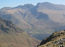
Sca fur
| Sca fur | ||
|---|---|---|
|
Sca fur |
||
| height | 964 m | |
| location | England | |
| Mountains | Cumbrian Mountains | |
| Coordinates | 54 ° 26 '50 " N , 3 ° 13' 28" W | |
|
|
||
The Sca Fell - sometimes also written Scafell by some authors like Alfred Wainwright - is one of the 214 Wainwright mountains (Fell) in the Lake District National Park in Northern England . With a height of 964 meters, it is the second highest point in England after Scafell Pike . It is connected to Scafell Pike by a rock ridge called Mickledore .
Originally the name Sca Fell was used to denote the entire surrounding massif. Recently, however, the term has only been used for the elevation south of the Mickledore.

It used to be assumed that the Sca Fell is the highest point in the entire range of mountains. In fact, when viewed from various vantage points and directions, it seems to tower over the elevations in its northern neighborhood. For this reason, the peaks known today as Scafell Pike, Ill Crag and Broad Crag were formerly known collectively as the "Pikes of Sca Fell".
While it is now known that the Sca Fell actually does not reach the height of the Scafell Pike, it remains the most difficult hill to conquer in the area for hikers. Both the craggy slopes surrounding it and the nearby moors make the ascent particularly difficult in foggy weather, as a path is then hardly to be found. On a beautiful day you can sit alone on the summit and watch the crowds in a calm and peaceful atmosphere, which are only one kilometer away on the summit of Scafell Pike, which is only 15 meters higher.
The direct ascent route starting from Wast Water is endangered today due to a rock fall in 2001 due to unstable rock. A longer alternative route to the summit starts at Boot in Eskdale , which is also the terminus of the Ravenglass and Eskdale Railway . It follows the upper reaches of the River Esk and then leads over the Foxes Tarn to the summit. As a descent route, the path to Burnmoor Tarn , which leads through the middle of the moorland, is ideal.
The massive east pillar of Sca Fell is one of the largest rocky cliffs in England and has several famous rock climbing routes.

