Schildthurn
|
Schildthurn
Zeilarn municipality
Coordinates: 48 ° 18 ′ 6 ″ N , 12 ° 51 ′ 37 ″ E
|
|
|---|---|
| Height : | 482 m above sea level NN |
| Residents : | 750 (2020) |
| Incorporation : | April 1, 1971 |
| Postal code : | 84367 |
| Area code : | 08572 |
|
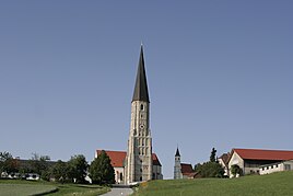
Pilgrimage church of St. Giles in Schildthurn, right next to it the chapel of St. Leonhard
|
|
Schildthurn is a district of the municipality of Zeilarn in the Lower Bavarian district of Rottal-Inn . Schildthurn is one and a half kilometers east of Zeilarn on state road 2590 in the Isar-Inn hill country .
On April 1, 1971, as part of the regional reform in Bavaria, the community of Schildthurn was merged with the communities of Gumpersdorf and Obertürken to form the new community of Zeilarn.
history
As early as the 9th century, Schildthurn was mentioned as a noble residence in Salzburg documents. Old spellings are Sciltaria , Schiltarum and Schiltarn . From 1076 to 1221 the nobles of Sciltaren are often listed as witnesses in documents from the Asbach , Raitenhaslach and Vornbach monasteries . After that, Schildthurn should have come into the possession of the Counts of Leonberg .
Attractions
See also: List of architectural monuments in Zeilarn # Schildthurn
- Pilgrimage Church of St. Giles
- St. Leonhard Chapel, built in the late 15th century
societies
- Schildthurn volunteer fire brigade, founded in 1885
- Schützengesellschaft Schildthurn, founded in 1950
literature
- Georg Dehio : Handbook of the German art monuments. Bavaria II. Lower Bavaria. 2nd edition, Deutscher Kunstverlag, Munich 2008, ISBN 978-3-422-03122-7 .
Web links
- Schildthurn in the location database of the Bavarian State Library Online . Bavarian State Library
- Schildthurn municipality in the Historical Atlas of Bavaria
- Zeilarn municipality

