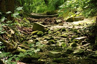
Schledde (Ahse)
| Schledde | ||
|
The Schledde stream bed that fell dry. |
||
| Data | ||
| Water code | DE : 278622 | |
| location | North Rhine-Westphalia , Germany | |
| River system | Rhine | |
| Drain over | Ahse → Lippe → Rhine → North Sea | |
| source | In Wippringsen 51 ° 30 ′ 18 ″ N , 8 ° 5 ′ 5 ″ E |
|
| Source height | 273 m above sea level NN | |
| muzzle | At Oestinghausen in the Ahse coordinates: 51 ° 37 '55 " N , 8 ° 6' 2" E 51 ° 37 '55 " N , 8 ° 6' 2" E |
|
| Mouth height | 71 m above sea level NN | |
| Height difference | 202 m | |
| Bottom slope | 12 ‰ | |
| length | 17.5 km | |
| Catchment area | 48.143 km² | |
| Medium-sized cities | Soest | |
The Schledde is a 17.5 km long orographic left tributary of the Ahse in North Rhine-Westphalia , Germany .
geography
The source of the Schledde lies on the Haarstrang on the southern outskirts of Wippringsen at an altitude of 270 m above sea level. NN . From here it flows mainly in a northerly direction. Their way leads them past the eastern outskirts of Soest . After 17.5 km the Schledde joins at 71 m above sea level. NN on the left side in the Ahse . On its way, the Ahse overcomes an altitude difference of 199 m, draining an area of 48.143 km².
Tributaries
- Lendringser Schledde - 4.1 km long, right tributary at 137 m above sea level. NN
- Supbieke - 1.5 km long, right tributary at 82 m above sea level. NN
- Bliebkesgraben - 2.2 km long, left tributary at 81 m above sea level. NN
- Roßbach - 1.7 km long, right tributary at 76 m above sea level. NN
- Kattroper Bach - 3.8 km long, left tributary at 76 m above sea level. NN
Surname
The name "Schledde" is identical to the regional name "Schledde", which occurs in the area around the northern roofing of the hairline, for a temporary body of water (or the valley of such a body of water). The German water body name book lists two possible derivations for the word “Schledde”, reconstructed German. Slidjō (to “glide” with relation to “Schlitz”) or reconstructed German. Slada (with related meanings such as “slope”, “ditch”, “ Valley").
Individual evidence
- ↑ a b German basic map 1: 5000
- ↑ a b c d e f g Topographical Information Management, Cologne District Government, Department GEObasis NRW ( information )
- ↑ a b c d e Topographic map 1: 25,000
- ^ Albrecht Greule (with the collaboration of Sabine Hackl-Rößler): Deutsches Gewässernamenbuch. Etymology of the names of bodies of water and the associated area, settlement and field names , Berlin / Boston 2014, ISBN 978-3-11-019039-7 , here: p. 472 entry "Schledde"


