Schlindermanderscheid
|
Schlindermanderscheid ( German ) Schlënnermanescht ( lux. ) community Burscheid
|
||
|---|---|---|
| Coordinates : | 49 ° 56 ' N , 6 ° 4' E | |
| Height : | 380 m | |
| Residents : | 255 (Oct 8, 2018) | |
| Postal code : | 9183 | |
|
Location of Schlindermanderscheid in Luxembourg
|
||
|
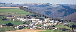
View of Schlindermanderscheid
|
||
Schlindermanderscheid ( Luxembourgish : Schlënnermanescht ) is a village in the municipality of Burscheid , Canton Diekirch , in the Grand Duchy of Luxembourg .
location
Schlindermanderscheid is located above the Sauer valley at an altitude of 380 meters. Goebelsmühle, which belongs to Schlindermanderscheid, is located south of the village, directly on the Sauer. There is also a train stop on the Luxembourg – Spa railway line here . The CR 348 runs through Schlindermanderscheid itself. Neighboring towns are Consthum in the north and Gralingen in the east .
General
Schlindermanderscheid is a small, rural place. The center of the village is the parish church of St Mary's birth, a simple hall church of Baroque . Almost all of the baroque interior has been preserved in the interior.
Web links
Individual evidence
- ↑ La commune en chiffres. In: Website of the municipality of Burscheid. Retrieved November 30, 2018 .


