Schloßberg (Pegnitz)
| Schlossberg | ||
|---|---|---|
|
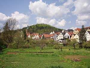
The Schloßberg with the city of Pegnitz |
||
| height | 543 m above sea level NHN | |
| location | Pegnitz , District of Bayreuth , Bavaria ( Germany ) | |
| Coordinates | 49 ° 45 '29 " N , 11 ° 31' 59" E | |
|
|
||
| particularities | - Burgstall Böheimstein - observation tower - Hoher Fels ( ND ) |
|
The Schloßberg is 543 m above sea level. NHN high mountain in the urban area of Pegnitz in the Upper Franconian district of Bayreuth , Bavaria .
Geographical location
The Schloßberg is located in the Franconian Switzerland-Veldenstein Forest Nature Park in the eastern part of Franconian Switzerland . It rises directly west of the town of Pegnitz, in which the Pegnitz rises on the eastern slope of the mountain .
Burgstall Böheimstein
On the mountain was in the Middle Ages , the castle Böheimstein , the 1357-1402 for the Czech kingdom belonged. It was destroyed by Nuremberg residents during the Second Margrave War in 1553 . Today only a wall reminds of the castle.
Lookout tower and natural monument
Since 1923 there has been an observation tower on the wooded Schloßberg with a good view of the city and the surrounding area. The Hoher Fels natural monument is located on the southern slope of the mountain .
Individual evidence
Web links
- Pegnitz observation tower , pictures of the Schloßberg and observation tower, on travel-bavaria.eu

