Schloßhofbach
| Schloßhofbach | ||
|
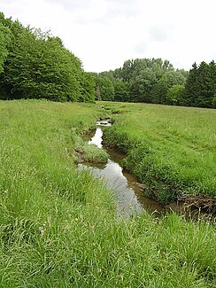
Renatured Schlosshofbach |
||
| Data | ||
| Water code | DE : 46432 | |
| location | North Rhine-Westphalia , Germany | |
| River system | Weser | |
| Drain over | Johannisbach → Werre → Weser → North Sea | |
| source | East of Bielefeld University 52 ° 1 ′ 59 ″ N , 8 ° 30 ′ 15 ″ E |
|
| Source height | approx. 127 m above sea level NN | |
| muzzle | In the Bielefeld district of Schildesche, coordinates: 52 ° 3 ′ 34 ″ N , 8 ° 32 ′ 0 ″ E 52 ° 3 ′ 34 ″ N , 8 ° 32 ′ 0 ″ E |
|
| Mouth height | approx. 87 m above sea level NN | |
| Height difference | approx. 40 m | |
| Bottom slope | approx. 12 ‰ | |
| length | 3.3 km | |
| Catchment area | 13.879 km² | |
| Left tributaries | Gellershagener Bach | |
| Right tributaries | Sudbrackbach | |
| Flowing lakes | Meierteich | |
The Schloßhofbach is a 3.3 km long orographically right tributary of the Johannisbach in North Rhine-Westphalia , Germany , which rises and flows in the area of the city of Bielefeld .
course
The source of the Schloßhofbach is located east of Bielefeld University near Kurt-Schumacher-Straße. The stream flows in a northeastern direction into the Schloßhofteich, the mill pond of the former Schloßhofmühle. Another source brook of the Schloßhofteich comes from the south, from Melanchthonstraße and flows west parallel to Schloßhofstraße through old clarifiers. The Schloßhofbach crosses under Schloßhofstrasse, continues in a north-easterly direction, crosses under the street Am Brodhagen, then through a green corridor with a rainwater retention basin and crosses under Jöllenbecker Strasse at the Stadtbahn stop Auf der Hufe. In the further course of the green corridor it flows through the Meierteich and Sudbrackteich. This is dammed up, the drain below the Sudbrackstraße is several meters lower. To the east of Sudbrackstraße, the stream enters the Bultkamp green corridor. After about 2.9 kilometers, the Sudbrackbach branches off to the right , which flows in again after crossing the Bultkamppark about 1.2 kilometers further north. Only a few meters after this tributary flows into the Gellershagener Bach from the left . About 150 meters further north, the Schloßhofbach crosses under Westerfeldstrasse and after another 50 meters joins the Johannisbach, which here runs parallel to Westerfeldstrasse to the north.
Characteristic
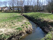
The Schloßhofbach shows a differently developed water structure . Above the Bultkamppark, the water flows through the settlement area and in this section is in a straightened and canal-like state. In contrast to this, the stream in the area of the park area, following renaturation measures towards the end of the 1980s, again leads through a near-natural, meandering bed. This section is designated as a biotope worthy of protection (BK-3917-222).
Water quality
Despite the renaturation measures, the water quality of the Schloßhofbach is in a critical condition according to an investigation in 2007. In addition to numerous discharges, the three bodies of water in the catchment area, Schloßhofteich, Sudbrackteich and Meierteich, probably also contribute to this.
Web links
Footnotes
- ↑ a b German basic map 1: 5000
- ↑ a b Topographical Information Management, Cologne District Government, Department GEObasis NRW ( Notes )
- ↑ a b Excerpt from the Bielefeld water quality report 2008 (PDF; 2.9 MB)
- ↑ NRW environmental data on site: Schloßhofbach with biotope mapping. In: GEO environmental portal NRW. https://www.uvo.nrw.de/ , accessed on July 17, 2019 .


