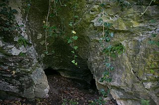
Silt cave
| Silt cave
|
||
|---|---|---|
| Location: | Kugelstein near Deutschfeistritz , Styria / A | |
| Height : | 471 m above sea level A. | |
|
Geographic location: |
47 ° 13 '30 " N , 15 ° 20' 18.2" E | |
|
|
||
| Cadastral number: | 2784/17 | |
| Geology: | Schöcklkalk | |
| Lighting: | No | |
| Overall length: | 6 m | |
| Level difference: | 0 m | |
The Schlufhöhle near Deutschfeistritz is 471 m above sea level. A. im Kugelstein north of the main town of Deutschfeistritz and south of Badl , Styria in Austria .
location
The Schlufhöhle is located on the eastern slope of the Kugelstein, north of Kugelsteinhöhle III and around 27 meters below the Ivy Cave and a little north below the Fuchsloch , not far from the municipal boundary between Deutschfeistritz and Frohnleiten . The access to the cave is in a small ledge.
description
Two low passages branch off from the entrance of the approximately 6-meter-long silt cave. The western corridor becomes impassable after about 3 meters. After around 2.7 meters, the northwest corridor becomes too low to be passable.
The cave floor is largely covered with cave clay. A detailed examination of the sediment deposits has not yet been carried out.
swell
- Heinrich Kusch : The caves in Kugelstein near Peggau (Styria) . In: The cave . tape 023 , 1972, p. 145–157 ( PDF (4.3 MB) on ZOBODAT ).

