
Scott Glacier (Marie Byrd Land)
| Scott Glacier | ||
|---|---|---|
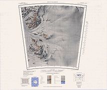
 The Scott Glacier in the eastern part of the topographic map sheet Mount Goodale 1: 250,000 |
||
| location | Marie-Byrd-Land , West Antarctica (politically: Ross Dependency ) | |
| Mountains | Transantarctic Mountains | |
| length | 200 km (roughly estimated) | |
| Coordinates | 85 ° 45 ′ S , 153 ° 0 ′ W | |
|
||
| drainage | Ross Ice Shelf | |

The Scott Glacier is a 200-kilometer-long glacier , of the central polar plateau near the D'Angelo Bluff and Mount Howe between the Nilsen Plateau of and the mountains Watson Escarpment flows and the Ross Ice Shelf west of the Tapley Mountains reached . The Scott Glacier flows into the westernmost part of the Gould Coast . To the west of the glacier is the Amundsen coast .
He was discovered in December 1929 by the team around the geologist Laurence McKinley Gould (1896-1995) during the first Antarctic expedition (1928-1930) of the American polar explorer Richard Evelyn Byrd . The Advisory Committee on Antarctic Names named it in 1966 after the British polar explorer Robert Falcon Scott (1868-1912).
Web links
- Scott Glacier in the Geographic Names Information System of the United States Geological Survey (English)
- Scott Glacier on geographic.org (English)

Southern part on the eastern edge of the map
South part on the western edge of the map


extreme southern part
