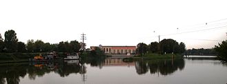
Neckar Canal Schwabenheim
| Neckar Canal Schwabenheim | |
|---|---|
| Water code | DE : 2389938 |
| location | Germany: Baden-Württemberg |
| length | 5.1 km |
| Built | 1927 |
| Expanded | 1990s |
| Beginning | Heidelberg , a little above the Wieblingen weir |
| The End | Dossenheim , a little below the Schwabenheim lock |
| Used river | Neckar |
| Competent authority | WSA Neckar |
| Estuary in Schwabenheim, on the right the Altneckar | |
The Neckar Canal Schwabenheim is a 5.1 kilometer long artificial waterway on the Neckar . It runs roughly between the Wieblingen weir and the Schwabenheim lock , northeast and parallel to the Altneckar , from which it is separated by a dam. The border between the districts and communities bordering the river runs in the Neckar. Therefore, the entire width of the canal lies in the area of Neuenheim , Handschuhsheim and Dossenheim on the right bank of the river. In the 1990s, the canal was expanded from a trapezoidal profile to a rectangular profile with a width of 38 meters for shipping. The target is at 105.26 m above sea level. NN .
The construction of the clearly located above the flow channel levels let the groundwater level in the voltage applied to the right side corridor Neuenheimer Feld from the Heidelberg district Neuenheim increase. For this reason, the new Heidelberg central cemetery, which was begun there in 1914, but was only partially completed and which was rededicated as a military cemetery in the course of the First World War, had to be abandoned . Today the Heidelberg Zoo is located on the site .
See also
Web links
- Picture gallery, pictures from yesterday, Wieblingen side canal, Heidelberg water and shipping authority
Individual evidence
- ↑ Side canals on the Neckar (PDF; 143 kB)
- ↑ The Ehrenfriedhof on the website of Via Monumentum, Association for the Preservation of Monuments in Heidelberg Cemeteries, accessed on May 25, 2014
- ^ History of the Heidelberg cemeteries on the website of the Heidelberg History Association (with map), accessed on May 25, 2014
Coordinates: 49 ° 25 ′ 30 ″ N , 8 ° 39 ′ 19 ″ E

