
Transmitter Zwiefalten (Danube Valley)
|
Transmitter Zwiefalten (Danube Valley)
|
||||
|---|---|---|---|---|
_I.JPG) |
||||
| Basic data | ||||
| Place: | Double folds | |||
| Country: | Baden-Württemberg | |||
| Country: | Germany | |||
| Altitude : | 699 m above sea level NHN | |||
| Coordinates: 48 ° 13 '24.9 " N , 9 ° 27' 54.6" E | ||||
| Use: | Broadcasting station | |||
| Mast data | ||||
| Building material : | steel | |||
| Data on the transmission system | ||||
| Waveband : | FM transmitter | |||
| Radio : | VHF broadcasting | |||
| Position map | ||||
|
||||


The transmitter Zwiefalten (Danube valley) is a filling station of the Südwestrundfunk (formerly the Südwestfunk ) for radio . It is located above and about one kilometer south of the village of Zwiefalten ( Reutlingen district ) on a wooded hill in the Schwarzlachenhau district . A free-standing steel framework mast is used as the antenna carrier.
From here, the community of Zwiefalten and the surrounding area are supplied with the SWR radio programs.
Until the introduction of DVB-T , this broadcaster broadcast the television program Das Erste .
Frequencies and Programs
Analog radio ( FM )
In the case of directed radiation, the main radiation directions are given in degrees in the antenna diagram.
|
Frequency (MHz) |
logo | Station name |
RDS (PS) |
RDS (PI) |
Regionalization |
ERP (kW) |
antenna | pole |
|---|---|---|---|---|---|---|---|---|
| 87.60 |
|
SWR4 Baden-Württemberg | SWR4_FN_ | DA04 | Bodensee radio | 0.1 | round | H |
| 92.80 |
|
SWR3 | __SWR3__ | D3A3 | Alb / Allgäu / Lake Constance | 0.1 | round | H |
| 93.70 |
|
SWR1 Baden-Württemberg | SWR1_BW_ | D301 | 0.1 | round | H |
Analog television (PAL)
Before the switch to DVB-T, the broadcasting location was still used for analog television:
| channel |
Frequency (MHz) |
program |
ERP (kW) |
Transmission diagram round (ND) / directional (D) |
Polarization horizontal (H) / vertical (V) |
|---|---|---|---|---|---|
| 9 | 203.25 | The First (SWR) | 0.005 | D (100-340 °) | H |
Picture gallery
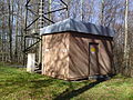
Transmitter house of the transmitter Zwiefalten (Danube valley)

Supply line from the transmitter house to the transmitter mast

Information sign on the transmitter house
_II.JPG)
_III.JPG)
_IV.JPG)