
Sfeçla
|
Sfeçël / Sfeçla 1 Svetlje / Светље 2 |
|||||
|
|||||
| Basic data | |||||
|---|---|---|---|---|---|
| State : |
|
||||
| District : | Pristina | ||||
| Municipality : | Podujeva | ||||
| Coordinates : | 42 ° 53 ' N , 21 ° 13' E | ||||
| Height : | 604 m above sea level A. | ||||
| Residents : | 1,739 (2011) | ||||
| Telephone code : | +383 (0) 038 | ||||
| License plate : | 01 | ||||
|
1 Albanian (indefinite / definite form) , 2 Serbian (Latin / Cyrillic spelling) 3 Kosovo's independence is controversial. Serbia continues to regard the country as a Serbian province. |
|||||


Sfeçla ( Albanian also Sfeçël , Serbian Светље Svetlje ) is a village in the municipality of Podujeva in northern Kosovo .
geography
Sfeçla is about 30 kilometers east of Mitrovica and about 30 kilometers north of Pristina near the road and railway line Niš- Pristina. Neighboring villages are Ballofc , Lladofc , Shajkofc , Dumosh , Siboc i Epërm , Gllamnik and Surkish . The city of Podujeva is around three kilometers from Sfeçla in the north.
population
The 2011 census showed a population of 1739 for Sfeçla. Of these, 1735 (99.77%) described themselves as Albanians .
| Census | 1948 | 1953 | 1961 | 1971 | 1981 | 1991 | 2011 |
|---|---|---|---|---|---|---|---|
| Residents | 765 | 812 | 954 | 1206 | 1522 | 1790 | 1739 |
Sons and daughters of the place
- Fadil Vokrri (1960-2018), football player
gallery

school
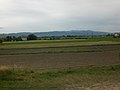
landscape
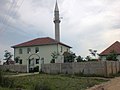
mosque


Individual evidence
- ↑ Popullsia e komunës së Podujevës sipas vendbanimit, gjinisë dhe etnicitetit 2011. In: rks-gov.net. Statistics Agency of Kosovo, accessed on July 4, 2017 (Albanian).
- ↑ Kosovo censuses. In: pop-stat.mashke.org. Retrieved December 7, 2019 .


Bajçina | Balloc | Baraina | Batllava | Bellasica | Bellopoja | Bërvenik | Bllata | Bradash | Braina | Breca | Burica | Dobërdol | Dobratin | Dumnica e Epërme | Dumnica e Poshtme | Dumosh | Dvorishta | Dyz | Gërdoc | Gllamnik | Godishnjak | Halabak | Hërtica | Kaçybeg | Kalatica | Kërpimeh | Kunushec | Kushevica | Letanca | Livadica | Lladoc | Llapashtica e Epërme | Llapashtica e Poshtme | Llausha | Lluga | Lluzhan | Lupç i Epërm | Lupç i Poshtëm | Majaca | Merdar | Metehia | Metergoc | Miroc | Muhazob | Murgulla | Obrança | Orllan | Pakashtica e Epërme | Pakashtica e Poshtme | Penuha | Peran | Përpellaca | Podujeva | Pollata | Popova | Potok | Radujeva | Rakinica | Reçica | Repa | Revuq | Sallabaja | Sfeçla | Shajkoc | Shakovica | Shtedim | Siboc i Epërm | Siboc i Poshtëm | Sllatina | Surdull | Surkish | Sylevica | Tërrnava | Tërrnavica | Turuçica | Velikareka | Zakut | Zhitia