
Shiroro Power Station
| Shiroro Power Station | |||
|---|---|---|---|
 |
|||
| location | |||
|
|||
| Coordinates | 9 ° 58 '30 " N , 6 ° 50' 4" E | ||
| country |
|
||
| Waters | Kaduna | ||
| Data | |||
| Type | Hydroelectric power plant | ||
| Primary energy | water | ||
| power | 600 MW | ||
| operator | Shiroro Hydro Electric Plc | ||
| Start of operations | 1990 | ||
| turbine | 4 Francis turbines | ||

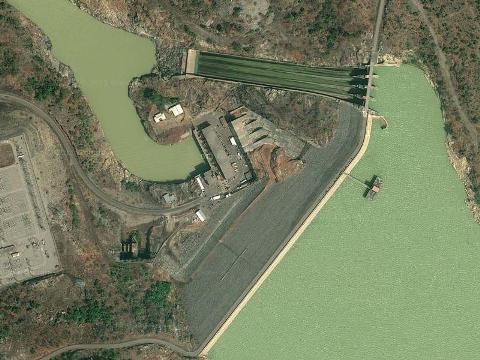
Shiroro Power Station is a hydroelectric power station on the Kaduna , a tributary of the Niger . The dam and power plant are located in the immediate vicinity of the city of Shiroro in the state of Niger in Nigeria .
The dam
The Shiroro barrier structure was built in 1984 in the form of a concrete pillar dam , the power plant has been in operation since 1990. With four water turbines , which are fed via four pressure lines with a diameter of 6.3 meters and a drop height of 97 meters, the power plant generates a total output of 600 megawatts and supplies around 400,000 households in the region with electricity. Shiroro Power Station is the second largest hydropower plant after the power plant on the Kainji Reservoir in Nigeria.
The operator is "Shiroro Hydro Electric Plc", a subsidiary of the Power Holding Company of Nigeria (PHCN). The annual energy production of this plant is specified by the operator as 2230 GWh , which corresponds to a utilization of around 42%.
One of the most important features of the Shiroro power plant in conjunction with other power plants in Nigeria is that each of the four power supply units can be started up within six minutes if required, peak demand or even if other power plants fail.
Technical specifications
- Power generation
- 4 water turbines Type: Francis turbine with a maximum speed of 150 / min
- 4 synchronous generators ( salient pole machine ) Type: internal pole design with a nominal voltage of 16 kV and 150 megawatts of power each
- Substation: 16 kV medium voltage to 330 kV high voltage for the overland supply.
- Dam structure
- Crown length: around 700 meters
- Width below: approx. 300 meters
- Width above: 7.50 meters with a single-lane residential street
- Dam height: the water level is 115 meters, to be on the safe side, the dam crown was raised by 5 meters to protect the top of the dam from the waves that can build up on the sea side due to wind pressure.
- The body of the dam does not have a central core seal; The tightness of the structure is ensured by a continuously poured reinforced concrete slab with specially arranged technology on the lake side.
- Flood relief , lateral overflow, is attached to the right abutment of the dam and is a reinforced concrete construction with a length of approx. 100 meters. The four openings are 15 meters wide and 16.65 meters high. The openings are controlled by hydraulically operated Tainter gates . The capacity of the overflows is around 7500 cubic meters per second. (see also photo under web links).
The reservoir
The lake, which is dammed up by the dam, has a length of 40 kilometers and an average width of about 6 kilometers. The Shiroro Reservoir has an estimated area of 320 km² and an average depth of around 22 meters holds almost 7 billion cubic meters of water.
See also
Individual evidence
- Jump up ↑ Shiroro Dam on global. britica.com, accessed August 1, 2013.
- ↑ Kainji, Shiroro, Jebba Dams ( page no longer available , search in web archives ) Info: The link was automatically marked as defective. Please check the link according to the instructions and then remove this notice. on leadership.ng, accessed August 1, 2013.
- ^ Company Overview of Shiroro Hydro Electric Plc at investing.businessweek.com, accessed August 1, 2013.
- ↑ Electrical Inspectorate Services, Federal Ministry of Power & Steel, Nigeria ( Memento of the original from November 20, 2008 in the Internet Archive ) Info: The archive link was inserted automatically and has not yet been checked. Please check the original and archive link according to the instructions and then remove this notice. on ecdc.net.cn, accessed August 1, 2013.
Web links
- Aerial photo of Shiroro Power Station on lgtnigeria.com, accessed August 1, 2013.
- Shiroro Hydropower Generation in the Lowland Areas of Middle River Niger (PDF; 919 kB) Technical data page 61 on hrmars.com, accessed August 1, 2013.