Tormantos
| Tormantos municipality | ||
|---|---|---|
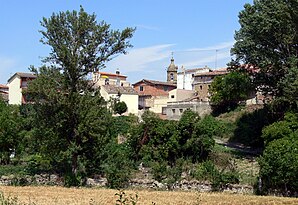
 Tormantos - the village with the Church of San Esteban
|
||
| coat of arms | Map of Spain | |
 Help on coat of arms |
|
|
| Basic data | ||
| Autonomous Community : |
|
|
| Comarca : | Santo Domingo de la Calzada | |
| Coordinates | 42 ° 30 ′ N , 3 ° 4 ′ W | |
| Height : | 608 msnm | |
| Area : | 11.07 km² | |
| Residents : | 131 (Jan. 1, 2019) | |
| Population density : | 11.83 inhabitants / km² | |
| Postal code : | 26213 | |
| Municipality number ( INE ): | 26150 | |
| administration | ||
| Website : | Ayuntamiento de Tormantos www.tormantos.org/ Ayuntamiento de Tormantos | |
Tormantos is a place and a municipality ( municipio ) on the middle reaches of the Río Tirón in the extreme west of the Spanish region La Rioja with about 131 inhabitants (as of January 1, 2019).
location
Tormantos is located about 60 kilometers west of Logroño at an altitude of about 600 meters above sea level. d. M. on the river Tirón. The next larger cities are Haro (23 kilometers northeast) and Miranda de Ebro (approx. 32 kilometers northeast). The small town of Santo Domingo de la Calzada , located on the Way of St. James , is about 15 kilometers to the south-east.
Population development
| year | 1960 | 1970 | 1981 | 1991 | 2001 | 2010 |
| Residents | 545 | 373 | 263 | 224 | 208 | 157 |
In the second half of the 19th and the first half of the 20th century, the place always had between 550 and 700 inhabitants. As a result of the mechanization of agriculture and the resulting lower demand for labor, the number of residents has declined significantly since the middle of the 20th century.
economy
In the first place in the economic life of the municipality traditionally ranks agriculture and especially viticulture. Tormantos belongs to the growing area of the Rioja Alta . In addition, wheat, barley, potatoes and various vegetables are cultivated.
history
The place is mentioned for the first time in a document from 1137. Nine years later he is included in the edict of Alfonso VII , in which the privileges and rights of self-government ( füros ) Cerezos were confirmed. A census in the 16th century came to around 200 inhabitants.
Attractions
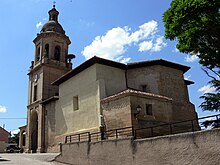
- The three-aisled church of San Esteban , built in the 16th century in honor of the arch martyr Stephen , had a smaller Romanesque predecessor. The square in the two lower floors, however, octagonal upstairs and a dome with sessile lantern crowned baroque tower is a construction of the 18th century; its basement is designed as an entrance hall ( portico ). There are several altarpieces inside the church ; the middle one shows the martyrdom of St. Stephen with the adjacent figures of the apostles Peter and Paul .
- The Palacio de Don Ruy López Dávalos , which was condestable under King John II of Castile , was originally a 15th century building; only the facade with a stone heraldic shield has survived. The palace was later converted into a convent and received a baroque bell gable ( espadaña ). Today the badly run-down building is used for residential purposes.
Web links
Individual evidence
- ↑ Cifras oficiales de población resultantes de la revisión del Padrón municipal a 1 de enero . Population statistics from the Instituto Nacional de Estadística (population update).

