Almarza de Cameros
| Almarza de Cameros municipality | ||
|---|---|---|
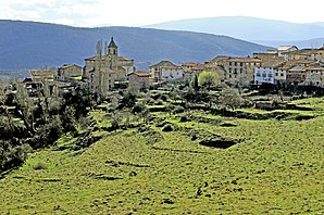
 Almarza de Cameros - town view
|
||
| coat of arms | Map of Spain | |

|
|
|
| Basic data | ||
| Autonomous Community : |
|
|
| Province : | La Rioja | |
| Comarca : | Camero Nuevo | |
| Coordinates | 42 ° 13 ′ N , 2 ° 36 ′ W | |
| Height : | 1060 msnm | |
| Area : | 28.11 km² | |
| Residents : | 36 (Jan. 1, 2019) | |
| Population density : | 1.28 inhabitants / km² | |
| Postal code : | 26111 | |
| Municipality number ( INE ): | 26012 | |
| administration | ||
| Website : | Almarza de Cameros | |
Almarza de Cameros is a mountain town and a municipality ( municipio ) belonging to the poorly populated region of the Serranía Celtibérica with a total of only 36 inhabitants (as of January 1, 2019) in the autonomous community of La Rioja in northern Spain .
Location and climate
The place Almarza de Cameros is located in a side valley of the Río Iregua a good 41 km (driving distance) southwest of the provincial capital Logroño at an altitude of about 1060 m . The climate is temperate to warm; Rain (approx. 635 mm / year) falls mainly in the winter half-year.
Population development
| year | 1857 | 1900 | 1950 | 1995 | 2018 |
| Residents | 261 | 269 | 154 | 39 | 28 |
As a result of the mechanization of agriculture , the abandonment of small farms and the resulting lower demand for labor, the number of inhabitants has declined significantly since the middle of the 20th century.
economy
For centuries, the community was agriculturally oriented for the purpose of self-sufficiency , with livestock farming (milk, cheese, meat, sausage) in the foreground. In addition, clothes were made from the sheep's wool shorn in the spring . Today holiday apartments (casas rurales) are rented out, especially in summer . The hamlet (pedanía) Ribavellosa , which belongs to the municipality and had 3 inhabitants in 2010, has since been abandoned.
history
Celtiberian , Roman , Visigoth and even Islamic-Moorish traces of settlement were not discovered in the municipality. The high-lying area served as summer pasture for sheep and goats for centuries . A military reconquest ( reconquista ) by the Christians did not take place, but the place was gradually settled as part of the Repoblación . In the Middle Ages, the region was disputed between the kingdoms of Castile and the Kingdom of Navarre . In 1366 Heinrich von Tratamara handed over 40 villages in the area of the Tierra de Cameros to his faithful Juan de Arellano, whose descendants ruled the area for a long time. After the abolition of the manorial system in 1811, it came to the old Castilian province of Soria and in 1822 to the newly created province of Logroño , from which the La Rioja region later emerged.
Attractions
- The Iglesia de Nuestra Señora del Campillo , built in the 16th century - with the exception of the corner stones - from rough rubble stones was built on the site of a previous Romanesque church , of which the baptismal font (pila bautismal) has been preserved. There are several grave slabs in the floor of the church .
- The old houses of the place consist of quarry stones and half-timbered with clay fillings.
- The local school, consisting of a single classroom, has been converted into a museum.
- Surroundings
- In the vicinity of the place there are several - partly ruinous - chapels (ermitas) .
Web links
- Almarza de Cameros - short information (wikirioja, Spanish)
- Almarza de Cameros - Photos and brief information (English)
Individual evidence
- ↑ Cifras oficiales de población resultantes de la revisión del Padrón municipal a 1 de enero . Population statistics from the Instituto Nacional de Estadística (population update).
- ↑ Almarza / Nieva de Cameros - climate tables
- ^ Almarza de Cameros - population development
- ↑ Almarza de Cameros - History and Sights
- ↑ Almarza de Cameros - Church

