Cervera del Río Alhama
| Cervera del Río Alhama municipality | ||
|---|---|---|
 Cervera del Río Alhama - place and castle hill
|
||
| coat of arms | Map of Spain | |

|
|
|
| Basic data | ||
| Autonomous Community : |
|
|
| Comarca : | Cervera | |
| Coordinates | 42 ° 0 ′ N , 1 ° 57 ′ W | |
| Height : | 550 msnm | |
| Area : | 152.58 km² | |
| Residents : | 2,294 (Jan 1, 2019) | |
| Population density : | 15.03 inhabitants / km² | |
| Postal code : | 26520 | |
| Municipality number ( INE ): | 26047 | |
| administration | ||
| Website : | Cervera del Río Alhama | |
Cervera del Río Alhama is a small town and a municipality ( municipio ) belonging to the populous Serranía Celtibérica with a total of only 2,294 inhabitants (as of January 1, 2019) in the southeast of the autonomous community of La Rioja in northern Spain .
Location and climate
The small town of Cervera del Río Alhama is located on the Río Alhama in the transition zone from the Iberian Mountains in the south to the Ebro Valley in the north and a good 95 km (driving distance) southeast of the provincial capital Logroño at an altitude of about 550 m ; to Saragossa it is another 125 km in a south-easterly direction. The climate is temperate to warm; Rain (approx. 480 mm / year) falls mainly in the winter half-year.
Population development
| year | 1857 | 1900 | 1950 | 2000 | 2018 |
| Residents | 3,970 | 5,930 | 7,374 | 2,960 | 2,298 |
As a result of the mechanization of agriculture , the abandonment of small farms and the resulting lower demand for labor, the population of the municipality has decreased significantly since the middle of the 20th century ( rural exodus ). The municipality also includes the villages (aldeas) or hamlets (pedanías) Cabretón , Las Ventas , Rincón de Olivedo , Valdegutur and Valverde with a total of about 800 inhabitants.
economy
For centuries, the community was agriculturally oriented for the purpose of self-sufficiency , with livestock farming (milk, cheese, meat) in the foreground; Weaving products were made from the sheep's wool and could also be exchanged or sold. But fruit, vegetables and grain were also grown. The production of espadrilles also played an important role in the economic life of the municipality. Today holiday apartments (casas rurales) are rented out mainly in the summer months .
history
Celtiberian traces were discovered on the castle hill, which are assigned to the pelendon and arevacian tribes . Roman , Visigoth and even Islamic-Moorish traces of settlement were not discovered in the municipality, but their presence can be assumed; We know from other sources that a Hispano-Roman or Visigothic family converted to Islam in the 8th century and ruled the place and its surroundings as Banu Qasi . A military recapture ( reconquista ) by the Christians may not have taken place, but the Christians gradually took power in the 12th century. In the further course of the Middle Ages, the region was at times disputed between the kingdoms of Castile and Navarre ; in 1196, however, Alfonso VIII of Castile conquered the city, which has since been part of Castile. In 1822 the city was added to the newly created province of Logroño , from which the autonomous region of La Rioja emerged in the 1980s.
Attractions
- The oldest building in the area is the castle (castillo) that has been rebuilt and rebuilt again and again - but today it is badly ruined .
- Parts of the old town are still characterized by medieval-Moorish streets and corners.
- The Iglesia de San Gil is the oldest church in town; however, it was rebuilt in the 15th and 17th centuries.
- The Basílica de Nuestra Señora del Monte also has medieval roots, but its current state dates from the 16th and 17th. Century.
- The Iglesia de Santa Ana is a foundation dating back to 1546. It has a monumental altarpiece (retablo) with side altars.
- Several chapels (ermitas) date from the 18th and 19th centuries.
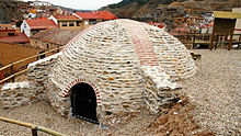
- In Barrio de San Miguel a stone's ice house from the 17th or 18th century preserved.
- Surroundings
- In the vicinity of the small town there are several medieval stone bridges (puentes) that were later often reworked .
Web links
- Cervera del Río Alhama - Photos + Info (Spanish)
Individual evidence
- ↑ Cifras oficiales de población resultantes de la revisión del Padrón municipal a 1 de enero . Population statistics from the Instituto Nacional de Estadística (population update).
- ↑ Cervera del Río Alhama - climate tables
- ^ Cervera del Río Alhama - population development
- ↑ Cervera del Río Alhama - History
- ↑ Cervera del Río Alhama - Sights
- ↑ Cervera del Río Alhama - Sights


