
Nájera
| Nájera municipality | |||
|---|---|---|---|
 Nájera
|
|||
| coat of arms | Map of Spain | ||

|
|
||
| Basic data | |||
| Autonomous Community : |
|
||
| Comarca : | Nájera | ||
| Coordinates | 42 ° 25 ′ N , 2 ° 44 ′ W | ||
| Height : | 485 msnm | ||
| Area : | 37.44 km² | ||
| Residents : | 8,045 (Jan 1, 2019) | ||
| Population density : | 214.88 inhabitants / km² | ||
| Postal code : | 26300 | ||
| Municipality number ( INE ): | 26102 | ||
| administration | |||
| Website : | Nájera | ||

Nájera is a small town and a 8,045 inhabitants (at January 1, 2019) counting municipality ( municipio ) at St. James ( Camino Francés ) in the autonomous region of La Rioja .
etymology
The earliest evidence of the name Nájera is from the year 923. Between 923 and 1225 the following forms of name can be identified: Nagara , Najela , Naiara , Nayra , Nasara , Naxera , Nazara , Naçara . Ramón Menéndez Pidal suspected that it was a pre-Romanesque name, others tried different Semitic derivations of the name, such as Hebrew nahar (נהר) or Arabic. nahr (نهر), 'river' or arab. nasir (نسر), 'eagle', could not convince with it so far. According to Fabián Gonzáles Bachiller, the etymology is therefore unclear.
Location and climate
The small town of Nájera is located on the Río Najerilla almost 30 km (driving distance) west of the provincial capital Logroño at an average altitude of about 485 m . The climate is temperate; Rain (approx. 555 mm / year) falls over the year.
Population development
| year | 1857 | 1900 | 1950 | 2000 | 2017 |
| Residents | 2,945 | 2,836 | 3,346 | 7,076 | 8,088 |
The increasing mechanization of agriculture in the 20th century resulted in a continuous loss of jobs in agriculture and thus a migration of many people to the cities.
economy
In the past, the residents of the place lived directly or indirectly (as farmers, agricultural workers or craftsmen) from farming and livestock farming. Today the service sector and especially tourism play an important role in the economic life of the municipality.

history
The area around Nájera was already settled in the Neolithic Age. In ancient times, the Roman city of Tritium Magallum was built around 2 km from today's city . The Moors founded a fortress on the Cerro de la Mota above the river. In 923 the Pamplona resident King Sancho I of Navarre conquered the area around Nájera; after the destruction of Pamplona by the troops of the Cordobesian emir Abd ar-Rahmans III. in 924 his son García I moved the capital to Nájera, but after the victorious campaigns of Almansor (around 990), the rulers of Navarre had to pay tributes to Córdoba. Sancho III. (ruled 999-1035) granted the city of Nájera extensive privileges ( fueros ) and promoted the pilgrimage to Santiago de Compostela by building hostels and hospitals. Four small empires emerged under his sons, but after successful battles against the Moors as part of the Reconquista, they formed the cradle of Navarre , Castile and Aragon . In the following years , the respective rulers equipped the city with buildings and other privileges - Nájera received full city rights (villa) in 1438 and the Santa María la Real monastery was built between 1435 and 1516 .
Attractions
- The most important building in Nájera is the monastery of Santa María la Real de Nájera , the burial place of the kings of Navarre and with a splendid late Gothic cloister .
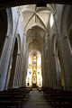
Monastery church

Main altar (retablo)

Cloister (claustro)

Pantéon de los Reyes

Pantéon de los Infantes

Sarcophagus Blankas of Castile († 1156)


_(3198308161)_(2).jpg)
- The construction of the Iglesia de la Santa Cruz began in 1611.
- The Convento de Santa Elena was a Poor Clare monastery .
- The Museo Najerillense presents numerous exhibits from the city's history.
See also
literature
- Cordula Rabe: Spanish Way of St. James. From the Pyrenees to Santiago de Compostela. All stages - with variants and height profiles. Bergverlag Rother, Munich 2008, ISBN 978-3-7633-4330-0 ( Rother hiking guide ).
- Bert Teklenborg: Cycling along the Camino de Santiago. From the Rhine to the western end of Europe. (Cycling guide, route planner). 3rd revised edition. Publishing House Tyrolia, Innsbruck 2007, ISBN 978-3-7022-2626-8 .
Web links
Individual evidence
- ↑ Cifras oficiales de población resultantes de la revisión del Padrón municipal a 1 de enero . Population statistics from the Instituto Nacional de Estadística (population update).
- ↑ Gonzáles Bachiller, Fabián: Toponomia de la Rioja , in: Gordón Peral, María Dolores: Toponimia de España: Estado actual y perspectivas de la investigación . Berlin / New York 2010, pp. 139–152.
- ↑ Nájera - climate tables
- ↑ Nájera - population development
- ^ Kingdom of Nájera - History
- ↑ Nájera - history
← Previous location: Navarrete (Rioja) 18 km | Nájera | Next town: Azofra 6 km →
Ábalos | Agoncillo | Aguilar del Río Alhama | Ajamil de Cameros | Albelda de Iregua | Alberite | Alcanadre | Aldeanueva de Ebro | Alesanco | Alesón | Alfaro | Almarza de Cameros | Anguciana | Anguiano | Arenzana de Abajo | Arenzana de Arriba | Arnedillo | Arnedo | Arrúbal | Ausejo | Autol | Azofra | Badarán | Bañares | Baños de Río Tobía | Baños de Rioja | Berceo | Bergasa | Bergasillas Bajera | Bezares | Bobadilla | Brieva de Cameros | Briñas | Briones | Cabezón de Cameros | Calahorra | Camprovín | Canales de la Sierra | Canillas de Río Tuerto | Cañas | Cárdenas | Casalarreina | Castañares de Rioja | Castroviejo | Cellorigo | Cenicero | Cervera del Río Alhama | Cidamón | Cihuri | Cirueña | Clavijo | Cordovín | Corera | Cornago | Corporales | Cuzcurrita de Río Tirón | Daroca de Rioja | Enciso | Entrena | Estollo | Ezcaray | Foncea | Fonzaleche | Fuenmayor | Galbárruli | Galílea | Gallinero de Cameros | Gimileo | Grañón | Grávalos | Haro | Herce | Herramélluri | Hervías | Hormilla | Hormilleja | Hornillos de Cameros | Hornos de Moncalvillo | Huércanos | Igea | Jalón de Cameros | Laguna de Cameros | Lagunilla del Jubera | Lardero | Ledesma de la Cogolla | Leiva | Leza de Río Leza | Logroño | Lumbreras | Manjarrés | Mansilla de la Sierra | Manzanares de Rioja | Matute | Medrano | Munilla | Murillo de Río Leza | Muro de Aguas | Muro en Cameros | Nájera | Nalda | Navajún | Navarrete | Nestares | Nieva de Cameros | Ochánduri | Ocón | Ojacastro | Ollauri | Ortigosa de Cameros | Pazuengos | Pedroso | Pinillos | Pradejón | Pradillo | Préjano | Quel | Rabanera de Cameros | El Rasillo de Cameros | El Redal | Ribafrecha | Rincon de Soto | Robres del Castillo | Rodezno | Sajazarra | San Asensio | San Millán de la Cogolla | San Millán de Yécora | San Román de Cameros | San Torcuato | San Vicente de la Sonsierra | Santa Coloma | Santa Engracia del Jubera | Santa Eulalia Bajera | Santo Domingo de la Calzada | Santurde de Rioja | Santurdejo | Sojuela | Sorzano | Sotés | Soto en Cameros | Terroba | Tirgo | Tobía | Tormantos | Torre en Cameros | Torrecilla en Cameros | Torrecilla sobre Alesanco | Torremontalbo | Treviana | Tricio | Tudelilla | Uruñuela | Valdemadera | Valgañón | Ventosa | Ventrosa | Viguera | Villalba de Rioja | Villalobar de Rioja | Villamediana de Iregua | Villanueva de Cameros | El Villar de Arnedo | Villar de Torre | Villarejo | Villarroya | Villarta-Quintana | Villavelayo | Villaverde de Rioja | Villoslada de Cameros | Viniegra de Abajo | Viniegra de Arriba | Zarratón | Zarzosa | Zorraquín