Portomarín
| Portomarín municipality | ||
|---|---|---|
| coat of arms | Map of Spain | |

|
|
|
| Basic data | ||
| Autonomous Community : |
|
|
| Province : | Lugo | |
| Comarca : | Comarca de Lugo | |
| Coordinates | 42 ° 48 ′ N , 7 ° 37 ′ W | |
| Area : | 115.1 km² | |
| Residents : | 1,471 (Jan 1, 2019) | |
| Population density : | 12.78 inhabitants / km² | |
| Postal code : | 27170 | |
| Municipality number ( INE ): | 27049 | |
| administration | ||
| Mayor : | Silvia Rodríguez Díaz ( PSdeG-PSOE , 2007) | |
| Website : | www.concellodeportomarin.es | |
| Location of the municipality | ||

|
||
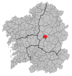
Portomarín is a place and a municipality on the edge of the Camino de Santiago in the province of Lugo in the autonomous community of Galicia ( Spain ). When the Belesar reservoir was built, the center of the village was rebuilt on the slope, next to the church of San Nicolas (town center) an old bridge arch (town entrance) and the portal front of the chapel of San Pedro (near the pilgrims' hostel) were removed and rebuilt at the new location .
history
There are numerous archaeological evidence in the municipality, the visible part of which is represented by the Celtiberi fortified villages called Castro. Examples are: Castro de Castromaior, Castro da Vires, Castro de Bedro, Castrolobrixe, Castro de Vila and the Castro de Soengas.
The construction of the first bridge over the Miño goes back to the Romans . In the second century it structurally connected the districts on the two opposite banks for the first time (later named San Pedro, left bank, and San Xoán, right bank), later directed the streams of pilgrims to Portomarin and made it the main pilgrimage station. The place was first mentioned in a document in 792 as "Portumarini".
In Liber Sancti Jacobi , Portomarín is called “Pons Minea” (Miño Bridge). Because of the few bridges over the Miño, it was an obligatory point of passage for the pilgrims of St. James. Thanks to the increasing number of pilgrims, it prospered and developed its greatest splendor between the 10th and 12th centuries. The importance Porto Marins in the Middle Ages emphasize the points equal to three Knights, who were in the city: on the left bank of the Miño had Santiagoritter and the Knights Templar settled on the right bank of the St. John . The warlike character of these orders is still reflected today in the fortified church of St. John (or San Nicolás), which is now in the center of the new Portomarin.
1112 destroyed Queen Urraca of León-Castile the bridge to the troops of her husband, I. Alfonso , stop. Eight years later, she ordered the reconstruction, led by a builder named Pedro Peregrinus (Peter the Pilgrim). Archbishop Pedro Arias transferred Portomarín to the newly founded order of the Santiago Knights.
In 1126, under the direction of Pedro Peregrino, a pilgrims' hospice was built, the facade of which was adorned with the words “Domus Dei” (House of God) and was looked after by the Santiago Knights. The building was demolished in 1944.
On February 8, 1946, Portomarín was declared an artistic-historical ensemble (Conxunto Histórico Artístico).
In 1956, the construction of the dam of the Belesar reservoir, forty kilometers away, began, whose waters would flood the place. Portomarín was therefore rebuilt on the terraces of Monte do Cristo on the right bank of the Miño. The old Portomarín disappeared under the rising water of the Belesar reservoir and is only visible again at very low water levels. The churches of San Nicolás and San Pedro (portal front), a bridge arch of the medieval bridges (Christina arch) and the palace of Count Maza, 16th century, and that of the Pimentales, also called Berbeteros, 17th century, were removed and rebuilt in the new location ., both standing in today's center.
structure
The Municipio Portomarin is divided into the Parroquias listed below , which were previously independent villages. The church patrons are listed in brackets:
Bagude (San Bertomeu), Belade (San Mamede), Caborrecelle (S. Xián), Castro de Soengas (S. Martiño), Castromaior (Sta. María), Cortapezas (Sta. María), Fiz de Rozas (S. Lourenzo) , Gonzar (Sta. María), León (San Martiño), Narón (Santa María), Nespereira (San Cibrán), Portomarín (San Nicolao), Portomarín (San Pedro), Recelle (San Pedro), O Río (San Mamede) , Sabadelle (San Salvador), Soengas (Santiago) and Vedro (San Martiño) Vilarbasín (San Pedro) Vilaxuste (San Pedro)
Population development of the municipality

Source: INE archive - graphic processing for Wikipedia
Festivals
Every year on Easter Sunday is here Fiesta de aguardiente (brandy festival) with a Schaub race and choosing the best orujo celebrated -Destillateurs.
Web links
Individual evidence
- ↑ Cifras oficiales de población resultantes de la revisión del Padrón municipal a 1 de enero . Population statistics from the Instituto Nacional de Estadística (population update).
- ↑ History Portmaríns (Span.)
- ↑ The municipality of Portomarín (span.)


