Uterga
| Uterga municipality | ||
|---|---|---|
 Panorama of Uterga
|
||
| coat of arms | Map of Spain | |

|
|
|
| Basic data | ||
| Autonomous Community : |
|
|
| Province : | Navarre | |
| Comarca : | Puente la Reina | |
| Coordinates | 42 ° 43 ′ N , 1 ° 46 ′ W | |
| Height : | 493 msnm | |
| Area : | 9.23 km² | |
| Residents : | 153 (Jan. 1, 2019) | |
| Population density : | 16.58 inhabitants / km² | |
| Postal code : | 31133 | |
| Municipality number ( INE ): | 31246 | |
| administration | ||
| Mayor : | Pedro María Nagore Lanas (2007) | |
Uterga is a small town on the Spanish Camino de Santiago , Camino Francés , in the autonomous community of Navarra . The place is in the Valle de Izarbe , in the lee of the Sierra del Perdón mountain range . The village's Gothic parish church is dedicated to the Assumption of Mary.
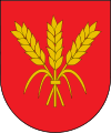
coat of arms
Description: Three upright golden ears of corn tied in red.
Population development of the municipality

Individual evidence
- ↑ Cifras oficiales de población resultantes de la revisión del Padrón municipal a 1 de enero . Population statistics from the Instituto Nacional de Estadística (population update).
- ↑ Location information from the regional government of Navarre (Spanish)
literature
- Míllan Bravo Lozano: Practical pilgrim guide. The Camino de Santiago. Editorial Everest, Léon 1994, ISBN 84-241-3835-X .
- Cordula Rabe: Spanish Way of St. James. From the Pyrenees to Santiago de Compostela. All stages - with variants and height profiles. Bergverlag Rother, Munich 2008, ISBN 978-3-7633-4330-0 ( Rother hiking guide ).
Web links
Commons : Uterga - collection of images, videos and audio files
Navigation bar St. James " Camino Francés "
← Previous location: Alto del Perdón 3 km | Uterga | Next town: Muruzábal 2.5 km →

