Tosantos
| Tosantos municipality | ||
|---|---|---|
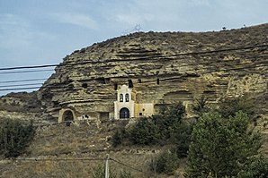
 Tosantos - Ermita de la Virgen de la Peña
|
||
| coat of arms | Map of Spain | |

|
|
|
| Basic data | ||
| Autonomous Community : | Castile and Leon | |
| Province : | Burgos | |
| Comarca : | Montes de Oca | |
| Coordinates | 42 ° 25 ′ N , 3 ° 15 ′ W | |
| Height : | 820 msnm | |
| Area : | 5.74 km² | |
| Residents : | 54 (Jan. 1, 2019) | |
| Population density : | 9.41 inhabitants / km² | |
| Postal code : | 09258 | |
| Municipality number ( INE ): | 09392 | |
| administration | ||
| Website : | Tosantos | |
Tosantos (short for Todos los Santos = "All Saints" / " All Saints ") is a place in northern Spain and a municipality ( municipio ) with only 54 inhabitants (as of January 1, 2019) in the east of the province of Burgos in the autonomous community of Castile. Leon . The municipality on the Way of St. James ( Camino Francés ) belongs to the poorly populated Serranía Celtibérica .
Location and climate
Tosantos is located in the headwaters of the Río Retorto , a tributary of the Río Tirón , a good 41 km (driving distance) east of Burgos at an altitude of approx. 820 m . The climate in winter is harsh, but in summer it is rather dry and warm; Rain (approx. 630 mm / year) falls mainly in the winter half-year.
Population development
| year | 1857 | 1900 | 1950 | 2000 | 2018 |
| Residents | 722 | 210 | 259 | 62 | 57 |
The mechanization of agriculture and the abandonment of small farms have led to a loss of jobs since the 1950s and, as a result, to a significant decline in the number of inhabitants ( rural exodus ).
economy
Agriculture, which also included some animal husbandry (e.g. pigs, sheep, chickens), has always played the most important role for the population of the region; Crafts, trade and service industries developed on a small scale in the village itself. Several houses in the village are now rented out as holiday apartments (casas rurales) .
history
Copper and Bronze Age as well as Celtic , Roman , Visigothic and Islamic-Moorish finds are missing. At the end of the 9th century the Castilian count Diego Rodríguez Porcelos recaptured large areas in the north of today's province of Burgos from the hands of the Moors (reconquista) ; then they were settled with Christians from the north (repoblación) .
Attractions
- The local parish church, built in the 17th century, is dedicated to the arch martyr Stephen (San Esteban) . Above the plain west facade of a three-piece is bell gable (espadaña) with a behind located bell chamber .
- The most important attraction of the community is the rock church of Nuestra Señora de la Peña ("Our Lady of the Rock"). It is approx. 16 m long, 7 m wide and 5 m high and mostly carved into a rock wall. In a small room behind the altar ( camarín ) it houses a Romanesque statue of the Virgin Mary from the 12th century.
- To the side and above the rock church are further rock caves in which former hermits may have lived.
- The local pilgrims' hostel is housed in a three-storey half - timbered house from the 19th century, which is typical for the region .
literature
- Míllan Bravo Lozano: Practical pilgrim guide. The Camino de Santiago. Editorial Everest, Léon 1994, ISBN 84-241-3835-X .
Web links
- Tosantos - photos + info (wikiburgos, spanish)
- Tosantos - photos + info (senditur, spanish)
- Romanesque in the Comarca Montes de Oca - photos + information (arteguias, Spanish)
Individual evidence
- ↑ Cifras oficiales de población resultantes de la revisión del Padrón municipal a 1 de enero . Population statistics from the Instituto Nacional de Estadística (population update).
- ↑ Tosantos - climate tables
- ↑ Tosantos - population development
- ↑ Tosantos - Ermita
← Previous location: Belorado 5 km | Tosantos | Next town: Villambistia 3 km →

