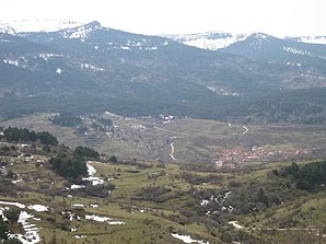
Neila (Burgos)
| Neila Parish | ||
|---|---|---|
 Neila - town view
|
||
| coat of arms | Map of Spain | |

|
|
|
| Basic data | ||
| Autonomous Community : |
|
|
| Province : | Burgos | |
| Comarca : | Sierra de la Demanda | |
| Coordinates | 42 ° 4 ′ N , 3 ° 0 ′ W | |
| Height : | 1000 msnm | |
| Area : | 68.59 km² | |
| Residents : | 154 (Jan. 1, 2019) | |
| Population density : | 2.25 inhabitants / km² | |
| Postal code : | 09679 | |
| Municipality number ( INE ): | 09232 | |
| administration | ||
| Website : | Neila | |
Neila is a northern Spanish town and a municipality ( municipio ) belonging to the poorly populated region of the Serranía Celtibérica with only 154 inhabitants (as of January 1, 2019) in the east of the province of Burgos in the autonomous community of Castile-León .
Location and climate
The place Neila is located in the headwaters of the Río Neila , a tributary of the Río Najerilla , on the southwest side of the Sierra de la Demanda at an altitude of about 1000 m . The city of Burgos is about 65 km (driving distance) in a north-westerly direction; It is almost 80 km to Soria in a south-easterly direction. The climate in winter is often harsh, but in summer it is mostly temperate and warm; Rain (approx. 590 mm / year) falls mainly in the winter half-year.
Population development
| year | 1857 | 1900 | 1950 | 2000 | 2018 |
| Residents | 653 | 497 | 465 | 233 | 158 |
The mechanization of agriculture and the abandonment of small farms led to a lack of jobs and a significant decline in the number of inhabitants ( rural exodus ) since the 1950s .
economy
In earlier times the area was used as a summer pasture; only gradually did some people remain permanent. Neila has been a remote and self-sufficient mountain village for centuries. Cattle breeding and with it the production of cheese , dried meat and wool played the most important roles in the economic life of the community. The field work is done by only a few farmers today; some houses are rented out as holiday apartments (casas rurales) in summer .
history
No evidence has yet been found from the Celtic , Roman , Visigothic and Islamic periods. In the 8th and early 9th centuries, the area was under Islamic influence, but the area was neither permanently settled nor defended by the Berbers due to the unusually harsh and rainy climate . At the end of the 9th century, the Castilian Count Diego Rodríguez Porcelos received from King Alfons III. of Asturias the order to repopulate ( repoblación ) the depopulated land. The place name was first mentioned in a document in 1044. From the 11th to the 14th century the place belonged to the municipal association Alfoz de Lara and experienced a heyday. From 1822 to 1833 the city and its surrounding area belonged to the Province of Logroño .
Attractions
- The Iglesia de San Miguel still has a Romanesque apse with a richly decorated window; however, that was nave (nave) modernized early 20th century. The upper parts of the bell tower (campanario) have also been renewed. The different construction phases can also be seen inside the church - while the nave has remained unadorned, Gothic fresco remains can be found in the apse calotte and the capitals also deserve attention. The richly reliefed Romanesque font (pila bautismal) still comes from the previous building.
- The Iglesia de Santa María also has a Romanesque origin, but it was almost completely rebuilt in the 14th century in the Gothic style of the time; the porch (portico) was added later. The rib vaults drawn down in the corners are noteworthy on the inside . The richly decorated Romanesque baptismal font still comes from the previous building, but the baroque gold-plated altarpiece defines the interior of the church.
- In the main square there is a court pillar (rollo or picota) - a sign of legal independence and freedom of the city.
- Many of the town's houses are made of natural stone; some have heraldic shields made of stone.
- Surroundings
- The Río Neila rises in the impressive Cueva de Neila cave .
- Two single arch medieval bridges cross the Río Neila; they also served as a means of crossing the cattle herds.
- A good 5 km southwest of the village is a group of six small lakes (Lagunas Altas) , all of which are remnants of Ice Age glaciers.
Web links
- Neila - short information (wikiburgos, Spanish)
- Neila, Romanesque churches etc. - photos + information (arteguias, Spanish)
Individual evidence
- ↑ Cifras oficiales de población resultantes de la revisión del Padrón municipal a 1 de enero . Population statistics from the Instituto Nacional de Estadística (population update).
- ↑ Neila / Quintanar de la Sierra - climate tables
- ↑ Neila - Population Development
- ↑ Neila - Story
- ↑ Neila - San Miguel
- ↑ Neila - San Miguel, font
- ↑ Neila - Santa María


